Ewell
| Ewell | |
|---|---|
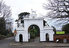
 Dog Gate Bourne Hall and Spring Street Ewell |
|
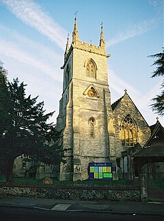
 Saint Mary the Virgin, parish church |
|
| Ewell shown within Surrey | |
| Area | 14.09 km2 (5.44 sq mi) |
| Population | 34,872 (2011 census) |
| • Density | 2,475/km2 (6,410/sq mi) |
| OS grid reference | TQ2263 |
| • London | 12.1 mi (19.5 km) |
| District | |
| Shire county | |
| Region | |
| Country | England |
| Sovereign state | United Kingdom |
| Post town | EPSOM |
| Postcode district | KT17 KT19 |
| Dialling code | 020 |
| Police | Surrey |
| Fire | Surrey |
| Ambulance | South East Coast |
| EU Parliament | South East England |
| UK Parliament | |
Ewell (/ˈjuːᵊl/ YOUW-el) is a suburban area in the borough of Epsom and Ewell in Surrey with a largely commercial village centre. Apart from this it has named neighbourhoods: West Ewell, Ewell Court, East Ewell, Ewell Grove, and Ewell Downs. One rural locality on the slopes of the North Downs is also a neighbourhood, North Looe. Remaining a large parish, Ewell occupies approximately the north-eastern half of the borough minus Stoneleigh.
It borders a south-west boundary of Greater London at Cheam and is within the capital's commuter belt and contiguous suburbs of the Greater London Built-up Area, 12 miles (19 km) from its centre. Ewell has the main spring, with an adjoining pond, at the head of the Hogsmill river, a small tributary of the River Thames. A majority – 73% – of the population of Ewell is in the ABC1 social class
The name Ewell derives from Old English æwell, which means river source or spring.
Bronze Age remains have been found in Ewell and the Romans are likely to have encountered an existing religious site when they first arrived leaving pottery, bones, and a few other remains, which have been taken to the British Museum. Ewell is on a long line of spring line settlements founded along the foot of hills on a geological line between the chalk of the North Downs to the south, and the clay of the London Basin to the north.
...
Wikipedia

