Evje og Vegusdal
| Evje og Vegusdal kommune | |
|---|---|
| Former Municipality | |

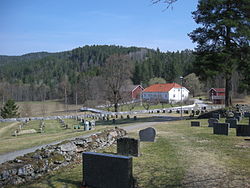
Evje Church cemetery and farm
|
|
| Location of the municipality | |
| Coordinates: 58°35′23″N 8°00′37″E / 58.5897°N 08.0104°ECoordinates: 58°35′23″N 8°00′37″E / 58.5897°N 08.0104°E | |
| Country | Norway |
| Region | Southern Norway |
| County | Aust-Agder |
| District | Setesdal |
| Municipality ID | NO-0934 |
| Adm. Center | Evje |
| Time zone | CET (UTC+01:00) |
| • Summer (DST) | CEST (UTC+02:00) |
| Created as | Formannskapsdistrikt in 1838 |
| Split into | Evje and Vegusdal in 1877 |
Evje og Vegusdal is a former municipality in Aust-Agder county, Norway. It was located in the Setesdal region in Southern Norway in parts of the present-day municipalities of Evje og Hornnes and Birkenes. The administrative centre was the village of Evje where the Evje Church is located.
The parish of Evje og Vegusdal was established as a municipality on 1 January 1838 (see formannskapsdistrikt). According to the 1835 census the municipality had a population of 1,627. On 1 January 1877, Evje og Vegusdal was divided to create two separate municipalities: Evje with a population of 870 and Vegusdal with a population of 935. These two municipalities later became parts of Evje og Hornnes and Birkenes respectively.
The municipality (originally the parish) of Evje og Vegusdal is named after the farms Evje and Vegusdal. The old Evje farm (Old Norse: Efja) is where the first Evje Church was built. The name is identical with the word efja which means "eddy", probably referring to the river Otra that runs past it. The old Vegusdal farm (Old Norse: Veikolfsdalr) is derived from the old male name, Veikolfr meaning "weak Ullfr" and the second part is the word dalr which means "valley", hence the "valley of weak Ullfr".
...
Wikipedia


