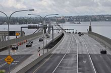
Evergreen Point Floating Bridge (2016)
| Evergreen Point Floating Bridge (2016) | |
|---|---|

Viewed from the east end in Medina shortly after opening in April 2016
|
|
| Coordinates | 47°38′27″N 122°15′33″W / 47.64080°N 122.25926°WCoordinates: 47°38′27″N 122°15′33″W / 47.64080°N 122.25926°W |
| Carries | 6 lanes of |
| Crosses | Lake Washington |
| Locale | Seattle, Washington |
| Official name | The SR 520 Albert D. Rosellini Evergreen Point Floating Bridge |
| Named for | Albert Rosellini |
| Owner | Washington State Department of Transportation (WSDOT) |
| Characteristics | |
| Design | Pontoon bridge |
| Material | Precast concrete |
| Total length | 7,710 feet (2,350 m) |
| Width | 116 feet (35 m) (at midpoint) |
| Design life | 75 years |
| History | |
| Construction cost | $4.56 billion (project budget) |
| Dedicated | April 2, 2016 |
| Opened | April 11–25, 2016 |
| Replaces | Evergreen Point Floating Bridge (1963–2016) |
| Statistics | |
| Toll | $0–$5.55 |
The Evergreen Point Floating Bridge, also known as the 520 Bridge and officially the Governor Albert D. Rosellini Bridge, carries Washington State Route 520 across Lake Washington from Seattle to its eastern suburbs. The 7,710-foot-long (2,350 m) floating span is the longest floating bridge in the world, as well as the world's widest measuring 116 feet (35 m) at its midpoint.
The bridge opened in April 2016 and replaced another floating bridge of the same name at the site, which was 130 feet (40 m) shorter.
The original Evergreen Point Floating Bridge, also named for state governor Albert D. Rosellini, opened on August 28, 1963, carrying the four-lane State Route 520 (at the time designated temporarily as the Evergreen Point branch of Primary State Highway 1 until the 1964 state highway renumbering). The 7,578-foot-long (2,310 m) floating span consisted of 33 pontoons and cost $24.7 million to construct (equivalent to $193 million in 2017); the bridge carried 4 lanes of traffic, separated by a curb that was later replaced with a simple Jersey barrier; at the center was a drawspan that opened for large vessels traversing the lake. The original bridge would also close to traffic during sustained wind gusts of 50 miles per hour (80 km/h) or higher for more than 15 minutes.
Due to increased traffic to and from the rapidly growing Eastside area, bridge replacement was explored as early as 1969, when building a parallel span was explored and rejected. The Eastside is also served by the Interstate 90 floating bridges completed in 1940 and 1989, carrying traffic through Mercer Island towards Bellevue.
...
Wikipedia
