Eva Site

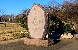
Eva Monument at Eva Beach
|
|
| Location |
Benton County, Tennessee, |
|---|---|
| Region | Benton County, Tennessee |
| Coordinates | 36°4′29.17″N 87°58′59.34″W / 36.0747694°N 87.9831500°W |
| History | |
| Cultures | Archaic period |
| Site notes | |
| Excavation dates | 1940 |
The Eva site (40BN12) is a prehistoric Native American site in Benton County, Tennessee, in the Southeastern United States. Located along an ancient channel of the Tennessee River, the Eva site saw extensive periods of occupation during the Middle and Late Archaic period (c. 6000-1000 BC). The site's well-defined midden layers helped investigators identify three distinct Archaic cultures, the oldest of which was first identified at Eva and is still known as the "Eva culture" or the "Eva phase."
The Eva site is now submerged by Kentucky Lake, an artificial reservoir created by the impoundment of the Tennessee River by Kentucky Dam. In 1940, before the Tennessee River was dammed to form Kentucky Lake, University of Tennessee archaeologists conducted excavations at the Eva site and managed to extract a relatively large amount of data. The data and artifacts were analyzed by University of Tennessee anthropologists Thomas Lewis and Madeline Kneburg Lewis, who presented their findings in a 1961 publication entitled Eva, an Archaic Site.
The Tennessee River enters the Benton County area from the south and proceeds northward for nearly 100 miles (160 km) before emptying into the Ohio River. Kentucky Dam, located nearly 80 miles (130 km) downstream from the Eva site, was completed in 1944 and created a lake that spans most of the state from north-to-south. Hills that comprise the western fringe of the Highland Rim rise as high as 300 feet (91 m) above the river to the east and west. The Eva site is named for the community of Eva, which is centered approximately 2 miles (3.2 km) to the southwest.
Before inundation by Kentucky Lake, the Eva site was located on a flood plain that stretched for nearly 2 miles (3.2 km) between the river bank and the hills to the west. This floodplain was characterized by a series of swells (natural levees created by river deposits) and swales (ancient river channels and tributary channels). The Eva site was situated on a high swell between a swale known as Three Mile Slough to the east and a swale known as the Cypress Creek Slough to the west. In Archaic times, the Tennessee River proper flowed through Three Mile Slough (roughly a mile west of its modern pre-inundation channel). As Three Mile Slough joins Cypress Creek immediately north of the Eva site, it's likely the site was situated at the ancient confluence of Cypress Creek and the Tennessee River.
...
Wikipedia

