Eureka Valley (San Francisco)
| Eureka Valley | |
|---|---|
| Neighborhood of San Francisco | |

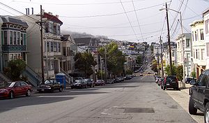
Eureka Valley, looking north on Castro Street from 20th. The giant rainbow flag at Castro and Market is just visible. In the summer months, fog tends to roll in over Twin Peaks and other hills to the west in the evenings and retreat again the next morning.
|
|
| Location within Central San Francisco | |
| Coordinates: 37°45′57″N 122°25′51″W / 37.76594°N 122.43093°W | |
| Government | |
| • Supervisor | Scott Wiener |
| • State Assembly | David Chiu (D) |
| • State Senator | Scott Wiener (D) |
| • U. S. Rep. | Nancy Pelosi (D) |
| Area | |
| • Total | 1.71 km2 (0.662 sq mi) |
| • Land | 1.71 km2 (0.662 sq mi) |
| Population (2008) | |
| • Total | 12,503 |
| • Density | 7,290/km2 (18,890/sq mi) |
| ZIP Code | 94110, 94114 |
| Area code(s) | 415 |
Eureka Valley is a neighborhood in San Francisco, primarily a quiet residential neighborhood but boasting one of the most visited sub-neighborhoods in the city, The Castro.
It is an affluent neighborhood popular with families and the LGBT community. The rainbow flag, signifying LGBT pride, can be seen displayed throughout the area. It was initially a working-class Irish neighborhood until a combination of factory jobs loss and the migration of gays into The Castro radically changed the neighborhood in the 1960s. In 1977, this district elected the first openly gay politician—Harvey Milk—to public office (San Francisco Board of Supervisors).
The only official definition of neighborhoods in San Francisco is by the city's Planning Department, which defines, a larger "Castro/Upper Market" neighborhood.
The definition of Eureka Valley by the Castro/Eureka Valley Neighbors Association as well as a 2007 Planning Department study is:
with Noe Valley to the south and Mission District to the east.
It encompasses several micro neighborhoods including The Castro and Duboce Triangle. Neighborhood associations defining sub-neighborhoods within Eureka Valley are: 19th Street (Noe to Sanchez), Buena Vista (BVNA), Corbett Heights, Corona Heights, Dolores Heights (DHIC), Duboce Triangle (DTNA), Hartford Street for Hartford (17th to 18th), and Mission Dolores.
In 1845 José de Jesús Noé was granted Rancho San Miguel, four thousand acres (16 km²) stretching from Twin Peaks into Noe and Eureka valleys. In 1854 John M. Horner purchased the ranch and laid out Horner's Addition in a grid bounded by Castro Street on the west, Valencia Street on the east, 18th Street on the north and 30th Street on the south. Eureka Valley was part of the Mission Dolores subdivision but was not developed until the 1890s and the early 1900s.
...
Wikipedia

