Esmeraldes-Pacific Colombia mangroves
| Esmeraldas-Pacific Colombia mangroves (NT1409) | |
|---|---|

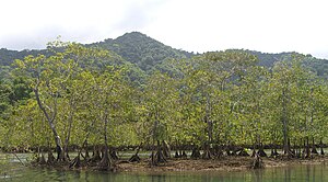
Mangroves along the shore of the Utría National Natural Park
|
|
| Ecology | |
| Realm | Neotropical |
| Biome | Mangroves |
| Geography | |
| Area | 6,500 km2 (2,500 sq mi) |
| Countries | Colombia, Ecuador |
| Coordinates | 4°12′32″N 77°30′32″W / 4.209°N 77.509°WCoordinates: 4°12′32″N 77°30′32″W / 4.209°N 77.509°W |
| Geology | Chocó, Tumaco Basins |
The Esmeraldas-Pacific Colombia mangroves (NT1409) is an ecoregion of mangrove forests along the Pacific coast of Colombia and Ecuador. It is threatened by human population growth, leading to over-exploitation for wood and clearance for farming and aquaculture.
Mangroves are found along the coast of Colombia and Ecuador from the Gulf of Tribugá in the north to Mompiche Bay in the south. Between these bays there are extensive stands of mangroves in the mouths of the San Juan, Naya, Guapi, Mira and Esmeraldas rivers. The mangroves cover 6,500 square kilometres (2,500 sq mi). The largest block is the almost continuous strip from the Mataje River to Chanzará bay near Guapi. In 1996 it was estimated that 2,927 square kilometres (1,130 sq mi) of mangroves were growing in the four Colombian Pacific coast departments. The mangroves border the Chocó-Darién moist forests ecoregion along most of the Pacific coast of Colombia. In the extreme south they border the Western Ecuador moist forests.
The ecoregion may be divided into two large zones to the north and south of Cabo Corrientes. In the northern section the continental shelf is narrow, with the land rising steeply from the shore to around 1,500 metres (4,900 ft) above sea level. Many small rivers supply clear water to the ecoregion year round. There are strong low-intensity upwellings along the coast.
The southern section fringes a flat sedimentary coastal plain with a broad continental shelf. There are no coastal upwellings. Rocks are mostly lutite, sandstone and conglomerates, with some limestone. The mangroves along the low, alluvial coast that stretches over 400 miles (640 km) from Cabo Corrientes into Esmeraldas Province are the largest mangrove area in northwest South America, forming the tidal fringe of the coastal plain 8 to 50 kilometres (5.0 to 31.1 mi) wide. There are large river deltas at the mouths of the Mataje, Mira, Patía, Sanquianga and Guapi rivers, and smaller deltas at the mouths of about 25 smaller rivers. There provide more fresh water than in the north, and often carry much more sediment. The mangrove forest strips run parallel to the coast in the southern section and may extend inland for as much as 20 kilometres (12 mi) due to the 4 metres (13 ft) tides.
...
Wikipedia
