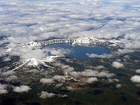
Eruption of Mount Mazama
| Mount Mazama | |
|---|---|

Mount Mazama collapsed into a caldera, which was filled with water to form Crater Lake.
|
|
| Highest point | |
| Elevation | 8,159 ft (2,487 m) |
| Listing | List of mountains of Oregon |
| Coordinates | 42°54′59″N 122°05′04″W / 42.9165186°N 122.0844711°WCoordinates: 42°54′59″N 122°05′04″W / 42.9165186°N 122.0844711°W |
| Geography | |
|
|
|
| Parent range | Cascade Range |
| Topo map | USGS Crater Lake East |
| Geology | |
| Mountain type | Caldera |
| Volcanic arc | Cascade Volcanic Arc |
| Last eruption | 2850 BCE |
| Climbing | |
| Easiest route | Drive |
Mount Mazama is a volcano in the Oregon segment of the Cascade Volcanic Arc and the Cascade Range located in the United States. The volcano's collapsed caldera holds Crater Lake, and the entire mountain is located within Crater Lake National Park. Its caldera was created by an eruption 42 times greater than the one of Mount St. Helens in 1980.
Mazama's summit was destroyed by a volcanic eruption that occurred around 5677 BC, ± 150 years. The eruption reduced Mazama's approximate 12,000-foot (3,700 m) height by about 1 mile (1,600 m). Much of the volcano fell into the volcano's partially emptied neck and magma chamber. At 8,159 feet (2,487 m), Hillman Peak is now the highest point on the rim.
The Klamath Native Americans of the area believed that the mountain was inhabited by Llao, their god of the underworld. After the mountain destroyed itself the Klamaths recounted the events as a great battle between Llao and his rival Skell, their sky god.
Much of what is known of Mazama's geology comes from a study by Howel Williams of the University of California, Berkeley and later, from USGS geologist Charles R. Bacon who expanded and modified Williams's work.
Mount Mazama was given its name in 1896 when a climbing club from Portland, The Mazamas, organized a visit to Crater Lake, and named the lost peak Mount Mazama after their club; the name being derived from a Native American word meaning "mountain goat".
...
Wikipedia

