Erme Estuary
|
River Erme |
|
|
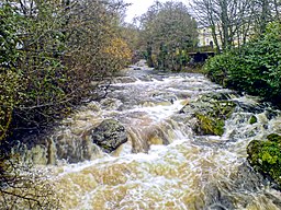
The Erme flowing through the town of Ivybridge
|
|
| Country | England |
|---|---|
| Counties | Devon |
| Source | |
| - location | Dartmoor |
| Mouth | English Channel |
| - location | Mothecombe |
| - coordinates | 50°18′29″N 3°57′03″W / 50.3080°N 3.9509°WCoordinates: 50°18′29″N 3°57′03″W / 50.3080°N 3.9509°W |
| Discharge | for Ermington |
| - average | 1.95 m3/s (69 cu ft/s) |
|
Map of the course and catchment of the River Erme
|
|
The Erme is a river in south Devon, England. From its source on Dartmoor it flows in a generally southerly direction past some of the best-preserved archaeological remains on the moor. It leaves the moor at the town of Ivybridge and continues southward, passing the settlements of Ermington, Modbury and Holbeton. Near Holbeton it becomes a ria and empties into the English Channel in Bigbury Bay, between the rivers Yealm and Avon.
The Ravenna Cosmography, an imperfect list of place-names that was compiled in the early 8th century from late Roman sources, lists amongst many others, over twenty names that probably refer to places in south-west England. Most of these have not been positively identified, but the name Aramis/Aranus/Armis was suggested to be the River Erme by Rivet and Smith in The Place-names of Roman Britain (1979).
The first certain documentary reference to the river is as Irym in the cartulary of Buckfast Abbey, dated 1240. Other early recorded forms are Hyrm, Irm, Erm and, in the mid 16th century, Arme. The derivation of the name remains unknown. Ekwall's suggestion that it is a back-formation from Ermington is now thought to be unlikely.Tristram Risdon, in his 1811 Survey of Devon gives an alternate name for the River Erme as the River Arme. He also refers to the mouth of the River Erme as Armouth. In Donn's map of Devon published in 1765, the village of Mothecombe at the mouth of the river, is referred to as Muddicomb.
The River Erme rises near the centre of southern Dartmoor on the Abbot's Way less than a mile to the south of the source of the River Plym. Between these two sources lies Duck's Pool, where there is a plaque and letterbox in memory of the Dartmoor author William Crossing. There are extensive early tin mining workings nearby known as Erme Pits, which are in places over 15 metres deep.
...
Wikipedia


