Erith
| Erith | |
|---|---|
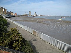
 William Cory Promenade along the River Thames frontage and Riverside Gardens |
|
| Erith shown within Greater London | |
| Population | 68,662 |
| OS grid reference | TQ505775 |
| • Charing Cross | 13.3 mi (21.4 km) WNW |
| London borough | |
| Ceremonial county | Greater London |
| Region | |
| Country | England |
| Sovereign state | United Kingdom |
| Post town | ERITH |
| Postcode district | DA8 |
| Dialling code | 01322 |
| Police | Metropolitan |
| Fire | London |
| Ambulance | London |
| EU Parliament | London |
| UK Parliament | |
| London Assembly | |
Erith (![]() i/ˈiːrᵻθ/) is a town next to the River Thames, in the London Borough of Bexley, south-east London, and the historic county of Kent, north-east of Bexleyheath and north-west of Dartford. Erith town centre has undergone modernisation and an increase in dwellings since 1961. The curved riverside high street contains three listed buildings, including the Church of England church and the Carnegie Building, while the district otherwise consists primarily of suburban homes. Erith is linked to central London and Kent by rail and a dual carriageway. It has the longest pier in London, and retains a coastal environment with salt marshes as well as industrial land.
i/ˈiːrᵻθ/) is a town next to the River Thames, in the London Borough of Bexley, south-east London, and the historic county of Kent, north-east of Bexleyheath and north-west of Dartford. Erith town centre has undergone modernisation and an increase in dwellings since 1961. The curved riverside high street contains three listed buildings, including the Church of England church and the Carnegie Building, while the district otherwise consists primarily of suburban homes. Erith is linked to central London and Kent by rail and a dual carriageway. It has the longest pier in London, and retains a coastal environment with salt marshes as well as industrial land.
Work carried out at the former British Gypsum site in Church Manorway by the Museum of London Archaeological Service shows that the area was covered by a dense forest of oak, yew, and alder during the Neolithic Period, which by the Bronze Age had given way in part to sedge fen.
...
Wikipedia

