Engi, Switzerland
| Engi | ||
|---|---|---|
| Village (and former municipality) | ||
 |
||
|
||
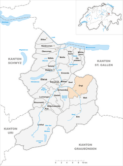
 The former municipal area (2007) |
||
| Coordinates: 46°59′N 9°9′E / 46.983°N 9.150°ECoordinates: 46°59′N 9°9′E / 46.983°N 9.150°E | ||
| Country | Switzerland | |
| Canton | Glarus | |
| Municipality | Glarus Süd | |
| Area | ||
| • Total | 40.7 km2 (15.7 sq mi) | |
| Elevation | 812 m (2,664 ft) | |
| Population (December 2015) | ||
| • Total | 609 | |
| • Density | 15/km2 (39/sq mi) | |
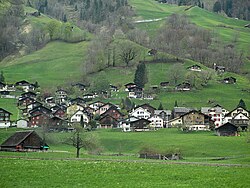
Engi is a village, and former municipality, in the municipality of Glarus Süd and canton of Glarus in Switzerland. The village lies in the valley of the Sernf river, and consists of the three adjacent village parts of Engi-Vorderdorf, Engi-Dörfli and Engi-Hinterdorf.
Engi is first mentioned in 1350 as ze engi.
From the 16th century, slate mining took place on the Landesplattenberg, overlooking the left bank of Sernf river, which provided slates for roofs, floors and stoves, and later for use in schools. From 1602 the trade was sufficient to support an export tax, and exports to northern and western Europe peaked in the 17th century. The operation declined in the following years, before again increasing with the construction of the first road up the valley in 1826. By 1840, nearly two hundred workers were working in the mine, which was abandoned in 1961 but is now preserved as a tourist attraction.
In 1879, the valley of the Linth river was connected to the Swiss railway network by the opening of the Swiss Northeastern Railway line from Weesen, but Engi, in the side-valley of the Sernf river, remained unserved. This impacted the local economy, and various proposals were brought forward to provide rail service to the Sernf valley. Eventually, on 8 July 1905, the Sernftal tramway, a metre gauge roadside electric tramway, was opened connecting Schwanden with Engi and other communities as far as Elm. Service on this line continued until 31 May 1969, when it was replaced by road services.
On 1 January 2011, Engi became part of the new municipality of Glarus Süd.
The village of Engi is situated at an elevation of 812 m (2,664 ft) on the right bank of the Sernf river. It includes the village sections of Vorderdorf, Dörfli and Hinterdorf, and is located on and near the road between Schwanden and Elm. The village of Schwanden lies downstream and to the west, whilst the village of Matt lies upstream and to the south.
...
Wikipedia

