Elstree Rural District
| Barnet Rural District Elstree Rural District (after 1941) |
|
|---|---|
| Area | |
| • 1911 | 10,820 acres (43.8 km2) |
| • 1974 | 8,339 acres (33.75 km2) |
| Population | |
| • 1901 | 4,154 |
| • 1971 | 33,586 |
| History | |
| • Created | 1894 |
| • Abolished | 1974 |
| • Succeeded by |
Barnet Urban District Hertsmere |
| Status | Rural district |
| • HQ | Council Offices, Shenley Road, Borehamwood |
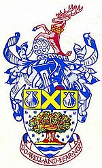
| • Motto | Do well and fear not |
 |
|
Elstree Rural District (until 1941 known as Barnet Rural District) was a rural district in Hertfordshire, England from 1894 to 1974.
It was formed under the Local Government Act 1894 as Barnet Rural District, as successor to the Barnet rural sanitary district. The rural district had an identical area to Barnet RSD except for the parish of South Mimms in Middlesex which went to form a single-parish South Mimms Rural District.
The district was renamed Elstree Rural District in 1941. It was abolished in 1974, and merged with other districts to form the non-metropolitan district of Hertsmere.
Over its existence the rural district consisted of the following civil parishes:
Arkley was formed from the rural part of the parish of Chipping Barnet in 1894. Totteridge constituted an exclave. Arkley became part of the Barnet Urban District in 1905, and was joined there by Totteridge in 1914.
In 1935 a county review order amended the area of the district with 1,176 acres of Elstree, Ridge and Shenley transferred to Barnet Urban District; 392 acres of Ridge and Shenley transferred to St Albans Rural District; and 692 acres of Aldenham gained from Watford Rural District.
On 20 March 1957, Armorial Bearings were granted. The arms and crest are described as follows:
Coordinates: 51°40′N 00°15′W / 51.667°N 0.250°W
...
Wikipedia
