Elsinore, UT
| Elsinore, Utah | |
|---|---|
| Town | |

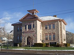
Elsinore's old White Rock Schoolhouse
|
|
| Nickname(s): Little Denmark | |
 Location in Sevier County and the state of Utah. |
|
| Coordinates: 38°41′4″N 112°8′51″W / 38.68444°N 112.14750°WCoordinates: 38°41′4″N 112°8′51″W / 38.68444°N 112.14750°W | |
| Country | United States |
| State | Utah |
| County | Sevier |
| Settled | 1874 |
| Named for | Elsinore |
| Area | |
| • Total | 1.3 sq mi (3.3 km2) |
| • Land | 1.3 sq mi (3.3 km2) |
| • Water | 0.0 sq mi (0.0 km2) |
| Elevation | 5,351 ft (1,631 m) |
| Population (2012) | |
| • Total | 845 |
| • Density | 581.8/sq mi (224.6/km2) |
| Time zone | Mountain (MST) (UTC-7) |
| • Summer (DST) | MDT (UTC-6) |
| ZIP code | 84724 |
| Area code(s) | 435 |
| FIPS code | 49-22650 |
| GNIS feature ID | 1440921 |
Elsinore is a town in Sevier County, Utah, United States. The population was 733 at the 2000 census.
The community was first settled in the spring of 1874 by James C. Jensen, Jens Iver Jensen, and others. The area was settled by Danish converts to The Church of Jesus Christ of Latter-day Saints, and named after Kronborg Castle, known as Elsinore in Hamlet. It was home to a Utah-Idaho Sugar Company factory for processing sugar beets into sugar from 1911 to 1929, but was closed due to a sugar beet blight.
According to the United States Census Bureau, the town has a total area of 1.3 square miles (3.3 km²), all of it land.
As of the census of 2000, there were 733 people, 261 households, and 196 families residing in the town. The population density was 581.8 people per square mile (224.6/km²). There were 287 housing units at an average density of 227.8 per square mile (87.9/km²). The racial makeup of the town was 95.50% White, 0.14% African American, 1.36% Native American, 0.27% Asian, 0.95% from other races, and 1.77% from two or more races. Hispanic or Latino of any race were 2.59% of the population.
...
Wikipedia
