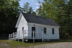
Ellsworth, New Hampshire
| Ellsworth, New Hampshire | |
|---|---|
| Town | |

Town hall
|
|
 Location in Grafton County, New Hampshire |
|
| Coordinates: 43°52′26″N 71°44′14″W / 43.87389°N 71.73722°WCoordinates: 43°52′26″N 71°44′14″W / 43.87389°N 71.73722°W | |
| Country | United States |
| State | New Hampshire |
| County | Grafton |
| Incorporated | 1769 |
| Area | |
| • Total | 21.5 sq mi (55.6 km2) |
| • Land | 21.4 sq mi (55.4 km2) |
| • Water | 0.1 sq mi (0.3 km2) 0.47% |
| Elevation | 1,174 ft (358 m) |
| Population (2010) | |
| • Total | 83 |
| • Density | 3.9/sq mi (1.5/km2) |
| Time zone | Eastern (UTC-5) |
| • Summer (DST) | Eastern (UTC-4) |
| ZIP code | 03223 |
| Area code(s) | 603 |
| FIPS code | 33-23860 |
| GNIS feature ID | 0873589 |
Ellsworth is a town in Grafton County, New Hampshire, United States. The population was 83 at the 2010 census.
Originally known as Trecothick, after Barlow Trecothick, a Bostonian who moved to London. He was an Alderman and MP and a Lord Mayor of the City of London. He had a country estate at Addington, London, which is now called Addington Palace.
The name of the town was changed to Ellsworth in 1802, in honor of Chief Justice Oliver Ellsworth.
The first census of the town, in 1800, reported 47 residents.
According to the United States Census Bureau, the town has a total area of 21.5 square miles (55.7 km2), of which 21.4 sq mi (55.4 km2) is land and 0.1 sq mi (0.3 km2) is water, comprising 0.47% of the town. The highest point in Ellsworth is the summit of Mount Kineo, at 3,313 feet (1,010 m) above sea level. Ellsworth lies fully within the Merrimack River watershed.
As of the census of 2000, there were 87 people, 32 households, and 19 families residing in the town. The population density was 4.1 people per square mile (1.6/km²). There were 72 housing units at an average density of 3.4 per square mile (1.3/km²). The racial makeup of the town was 96.55% White, and 3.45% Native American.
...
Wikipedia
