Eleuthera

Map showing showing the main island of Eleuthera, with Russel, Royal, Harbour, and Windermere Islands and associated Cays, other geographical features, and concentrations of population. By Joachim Greiner, 2009.
|
|
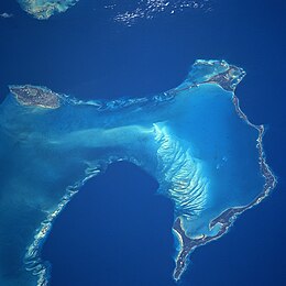
| NASA satellite image, showing New Providence Island to the west, and east of it, the long, narrow island of Eleuthera running north and south (along with its associated Harbour and other small islands), as seen from space in 1997. | |
| Geography | |
|---|---|
| Coordinates | Coordinates: 25°06′N 76°08′W / 25.100°N 76.133°W |
| Archipelago | Bahamas |
| Adjacent bodies of water | Caribbean |
| Total islands | TBD |
| Major islands | TBD |
| Area | 457.4 km2 (176.6 sq mi) |
| Length | 180 km (112 mi) |
| Width | 1.6 km (0.99 mi) |
| Highest elevation | 61 m (200 ft) |
| Administration | |
| Districts | North Eleuthera, Central Eleuthera, South Eleuthera |
| Demographics | |
| Population | 8,326 (2000) |
| Pop. density | 18.20 /km2 (47.14 /sq mi) |
| Ethnic groups | 85% black (esp. West African), 12% European, 3% other |
Eleuthera /iˈluːθərə/ refers both to a single island in the modern nation of the Bahamas, and to that island and its associated group of small islands. Sometimes referred to as Eleuthera and Harbour Island (adding a single large component island of the group), "Eleuthera" derives from the feminine Greek adjective (eleutheros), meaning "free". Known in the 17th century as Cigateo, it lies 80 km (50 miles) east of Nassau. It is long and thin—180 km (110 miles) long and in places little more than 1.6 km (1.0 mile) wide. Its eastern side faces the Atlantic Ocean, and its western side faces the Great Bahama Bank. The topography of the island varies from wide rolling pink sand beaches to large outcrops of ancient coral reefs, and per a 2000 census, its human population numbered approximately 8,300.
The name Eleuthera refers both to a single Bahamian island, and can also be used to refer to that island and its associated group of small islands; it is sometimes also referred to as Eleuthera and Harbour Island, adding a single large component island of the group (for instance, in the official web materials of the Bahamas.
The main island lies 80 km (50 miles) east of Nassau, and it is a long and thin island—180 km (110 miles) long and little more than 1.6 km (1.0 mile) wide at its narrowest. The island has an estimated area of 457.4 square-kilometers, and presents 336 km (210 miles) of coastline.
Its eastern side faces the Atlantic Ocean, and its western side faces the Great Bahama Bank. The topography of the island varies from wide rolling pink sand beaches to large outcrops of ancient coral reefs.
The island features, among other flora and fauna, 13 catalogued species of native amphibian and reptile species, three of which were listed as endangered in 2000.
The original population of Taino, or Arawaks, was mostly deported by the Spanish to work in the mines of Hispaniola, where they died out by 1550. The island—then named Cigateo—is believed to have been virtually unoccupied until the first European settlers—puritan pilgrims—arrived in 1648 from Bermuda. These settlers, known as the "Eleutherian Adventurers", gave the island its current name—ἐλευθερία eleutheria which derives from the feminine form of the Greek adjective , eleutheros, meaning "free". Difficulties ultimately left only a few of this original population on the island; had these Puritan pioneers succeeded in their aim, they would have created the first democracy in the Western Hemisphere, almost 130 years prior to the American Revolution.
...
Wikipedia

