Electoral district of Bentleigh
|
Bentleigh Victoria—Legislative Assembly |
|
|---|---|

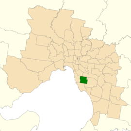
Location of Bentleigh (dark green) in Greater Melbourne
|
|
| State | Victoria |
| Created | 1967 |
| MP | Nick Staikos |
| Party | Labor |
| Electors | 40,981 (2014) |
| Area | 21 km2 (8.1 sq mi) |
| Demographic | Metropolitan |
| Coordinates | 37°55′S 145°03′E / 37.917°S 145.050°ECoordinates: 37°55′S 145°03′E / 37.917°S 145.050°E |
The Electoral district of Bentleigh is an electoral district of the Victorian Legislative Assembly. It covers an area of 21 square kilometres (8.1 sq mi) in southern Melbourne, including the suburbs of Bentleigh, Hampton East, McKinnon, and Moorabbin, and parts of Bentleigh East, Brighton East and Ormond. It also includes the Moorabbin campus of the Monash Medical Centre. It lies within the Southern Metropolitan Region of the upper house, the Legislative Council.
Bentleigh has usually been seen as a key marginal seat, lying at the 'point of the pendulum' needed to change government. It was Liberal held from its creation in 1967 until the 1979 election where the Liberals nearly lost their majority for the first time in just under three decades. Labor then held the seat until the Kennett landslide of 1992. Following this, the seat was narrowly held by Inga Peulich until she was tipped out of office by Rob Hudson in the 2002 election. In the 2010 election the seat returned to the Liberal party with Elizabeth Miller narrowly defeating Rob Hudson. She was ousted by Labor candidate Nick Staikos at the 2014 election.
...
Wikipedia
