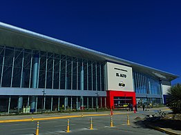
El Alto International Airport
|
El Alto International Airport Aeropuerto Internacional El Alto |
|||||||||||||||
|---|---|---|---|---|---|---|---|---|---|---|---|---|---|---|---|

Main terminal
|
|||||||||||||||
| Summary | |||||||||||||||
| Airport type | Public / Military | ||||||||||||||
| Owner | Government of Bolivia | ||||||||||||||
| Operator | SABSA S.A. | ||||||||||||||
| Serves | La Paz, Bolivia | ||||||||||||||
| Location | El Alto, Bolivia | ||||||||||||||
| Hub for | |||||||||||||||
| Focus city for | |||||||||||||||
| Elevation AMSL | 4,061.5 m / 13,325 ft | ||||||||||||||
| Coordinates | 16°30′48″S 068°11′32″W / 16.51333°S 68.19222°WCoordinates: 16°30′48″S 068°11′32″W / 16.51333°S 68.19222°W | ||||||||||||||
| Website | www |
||||||||||||||
| Map | |||||||||||||||
| Location of airport in Bolivia | |||||||||||||||
| Runways | |||||||||||||||
|
|||||||||||||||
| Statistics (2013) | |||||||||||||||
|
|||||||||||||||
|
Source: SABSA, Airport Statistics
|
|||||||||||||||
| Passengers | 1,793,668 |
|---|
El Alto International Airport (Spanish: Aeropuerto Internacional El Alto) (IATA: LPB, ICAO: SLLP) is an international airport located in the city of El Alto,Bolivia, 8 mi (13 km) south-west of La Paz. At an altitude of 4,061.5 m (13,325 ft), it is the highest international airport and the fifth highest commercial airport in the world.
The airport has served since the first half of the 20th century, but was modernized in the late 1960s, when its runway was lengthened and a new passenger terminal with modern facilities was built. The new airport was inaugurated in 1965. El Alto airport was a primary hub for the former Lloyd Aéreo Boliviano, Bolivia's flag carrier which ceased operations in 2007 and is a hub for Transporte Aéreo Militar and Línea Aérea Amaszonas. It serves also as a focus city for Boliviana de Aviación which is a state owned airline.
The Bolivian territory is characterized by extremely varied terrain. These topographic aberrations, which include a variety of environments such as rugged mountains, high plateaus, low valleys and tropical forests, as well as the country's large size, had a negative effect on national transportation, making communication difficult between elevated and low cities along with isolated tropical towns. What finally overcame the geographical difficulties was aviation. This source of communication was very effective since some populations, in most cases, depend exclusively on the air transport for being able to communicate.
The Bolivian air transport started in 1916, when the Military school of Aviation (Spanish: Escuela Militar de Aviación) was formed in La Paz. In 1929 the local government made a project for the construction of the airport. However it was officially inaugurated in the 1960s. In 1974 the airport proceeded to a reconstruction. A new terminal was built and its facilities were enlarged and modernized. Until 1999 the airport took John F. Kennedy (JFK) as the official name although in practice this name was never used in a public way. In that year, before the pressure of different sectors, by means of the Law 1944 during the government of Hugo Banzer Suárez the airport changed its name officially to El Alto International Airport as a de facto name up to that moment.
...
Wikipedia

