Eigg
| Gaelic name | Eige |
|---|---|
| Pronunciation | [ˈekʲə] |
| Norse name | Unknown |
| Meaning of name | Scottish Gaelic for 'notched island' (eag) |
 An Sgurr |
|
| Location | |
|
Eigg shown within Lochaber
|
|
| OS grid reference | NM476868 |
| Coordinates | 56°54′N 6°09′W / 56.9°N 6.15°W |
| Physical geography | |
| Island group | Small Isles |
| Area | 3,049 hectares (11.8 sq mi) |
| Area rank | 28 |
| Highest elevation | An Sgurr 393 metres (1,289 ft) |
| Administration | |
| Sovereign state | United Kingdom |
| Country | Scotland |
| Council area | Highland |
| Demographics | |
| Population | 83 |
| Population rank | 47 |
| Pop. density | 2.7 people/km2 |
| Largest settlement | Cleadale |
| References | |
| Pronunciation | ||
|---|---|---|
| Scots Gaelic: | An Laimhrig | |
| Pronunciation: | [əˈlˠ̪ajvɾʲɪkʲ] | |
| Scots Gaelic: | Clèadail | |
| Pronunciation: | [ˈkʰliət̪al] | |
| Scots Gaelic: | Eige | |
| Pronunciation: | [ˈekʲə] | |
| Scots Gaelic: | Uamh Fhraing | |
| Pronunciation: | [ˈuəv ˈɾaŋʲkʲ] | |

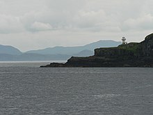
Eilean Chathastail lighthouse viewed from the Mallaig-Eigg ferry.
|
|
| Location |
Eilean Chathastail Eigg Inner Hebrides Scotland United Kingdom |
|---|---|
| Coordinates | 56°52′15″N 6°07′17″W / 56.870913°N 6.121394°W |
| Year first constructed | 1906 |
| Construction | metal tower |
| Tower shape | cylindrical tower with balcony and lantern |
| Markings / pattern | white tower and lantern |
| Height | 8 metres (26 ft) |
| Focal height | 24 metres (79 ft) |
| Light source | solar power |
| Characteristic | Fl W 6s. |
| Admiralty number | A4080 |
| NGA number | 4012 |
| ARLHS number | SCO-066 |
| Managing agent | Isle of Eigg Heritage Trust |
Eigg (/ɛɡ/; Scottish Gaelic: Eige, [ˈekʲə]) is one of the Small Isles, in the Scottish Inner Hebrides. It lies to the south of the Skye and to the north of the Ardnamurchan peninsula. Eigg is 9 kilometres (5.6 mi) long from north to south, and 5 kilometres (3.1 mi) east to west. With an area of 12 square miles (31 km2), it is the second largest of the Small Isles after Rùm.
Notably, Eigg generates virtually 100% of its electricity using renewable energy.
The main settlement on Eigg is Cleadale, a fertile coastal plain in the north west. It is known for its quartz beach, called the "singing sands" (Tràigh a' Bhìgeil) on account of the squeaking noise it makes if walked on when dry.
The centre of the island is a moorland plateau, rising to 393 metres (1,289 ft) at An Sgurr, a dramatic stump of pitchstone, sheer on three sides. Walkers who complete the easy scramble to the top in good weather are rewarded with spectacular views all round of Mull, Coll, Muck, the Outer Hebrides, Rùm, Skye, and the mountains of Lochaber on the mainland.
...
Wikipedia

