Ehrenfeld, Pennsylvania
| Ehrenfeld, Pennsylvania | |
|---|---|
| Borough | |

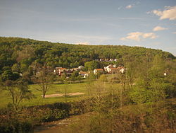
Ehrenfeld from a passing Pennsylvanian train
|
|
| Coordinates: 40°22′20″N 78°46′35″W / 40.37222°N 78.77639°WCoordinates: 40°22′20″N 78°46′35″W / 40.37222°N 78.77639°W | |
| Country | United States |
| State | Pennsylvania |
| County | Cambria |
| Incorporated | 1956 |
| Government | |
| • Type | Borough council |
| Area | |
| • Total | 0.44 sq mi (1.15 km2) |
| • Land | 0.43 sq mi (1.12 km2) |
| • Water | 0.01 sq mi (0.03 km2) |
| Elevation | 1,837 ft (560 m) |
| Population (2010) | |
| • Total | 228 |
| • Density | 528/sq mi (203.9/km2) |
| Time zone | Eastern (EST) (UTC-5) |
| • Summer (DST) | EDT (UTC-4) |
| ZIP code | 15956 |
| Area code(s) | 814 |
Ehrenfeld is a borough in Cambria County, Pennsylvania, United States. It is part of the Johnstown, Pennsylvania Metropolitan Statistical Area. The population was 228 at the 2010 census.
Ehrenfeld is located in south-central Cambria County at 40°22′20″N 78°46′35″W / 40.37222°N 78.77639°W (40.372273, -78.776394), in the valley of the Little Conemaugh River. It is bordered to the east by the borough of Summerhill and to the southwest by the borough of South Fork. U.S. Route 219 passes through the eastern part of Ehrenfeld, with access from one exit (Pennsylvania Route 53). US 219 leads north 10 miles (16 km) to Ebensburg, the county seat, and southwest 33 miles (53 km) to Somerset. Johnstown, the largest city in Cambria County, is 13 miles (21 km) to the southwest via US 219 and Pennsylvania Route 56.
According to the United States Census Bureau, the borough of Ehrenfeld has a total area of 0.44 square miles (1.15 km2), of which 0.43 square miles (1.12 km2) is land and 0.01 square miles (0.03 km2), or 2.98%, is water.
...
Wikipedia

