Egham Hythe
| Egham Hythe | |
|---|---|
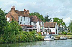
 The Swan Inn |
|
 One of the large modern business, storage, industrial and retail premises on The Causeway |
|
| Egham Hythe shown within Surrey | |
| Area | 1.91 km2 (0.74 sq mi) |
| Population | 6,474 (2011. Runnymede Ward) |
| • Density | 3,390/km2 (8,800/sq mi) |
| OS grid reference | TQ025705 |
| • London | 17.8 mi (28.6 km) |
| District | |
| Shire county | |
| Region | |
| Country | England |
| Sovereign state | United Kingdom |
| Post town | STAINES-UPON-THAMES |
| Postcode district | TW18 |
| Dialling code | 01784 |
| Police | Surrey |
| Fire | Surrey |
| Ambulance | South East Coast |
| EU Parliament | South East England |
| UK Parliament | |
Egham Hythe is a ward historically only in Egham, split into two post towns in Surrey, England. It is on the south bank of the River Thames between Runnymede and Thorpe and has a road to junction 13 of the M25, the Causeway, hosting major businesses. Its northern half, as such, has many of the largest businesses of north Surrey and its southern half includes the largely residential locality Pooley Green.
Egham Hythe is west south-west of Charing Cross and has been bypassed by the A30 since the 1950s. Egham Hythe has Staines Boat Club and four pubs. It has a large riverside inn and hotel facing the inn, in a conservation area known as the Hythe, meaning port in Old and Middle English. One end of Staines Bridge, a 'local road' crossing of the river, connects Egham Hythe to Staines and the Thames Path crosses from one bank to the other.
In the centuries around the time of the Norman Conquest the tything of the Hythe, which belonged to Chertsey Abbey, supported only shepherd's tenements and lowly agriculture dwellings due to flooding quite often by the river Thames. The consistent use of the Hythe in ecclesiastical records, Assize Rolls and feet of fines denotes that Anglo-Saxon speakers ran an inland port here, as hythe means port in Old and Middle English. The other three Egham tythings were:
...
Wikipedia

