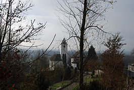
Eggenwil
| Eggenwil | ||
|---|---|---|
 |
||
|
||
| Coordinates: 47°22′N 8°20′E / 47.367°N 8.333°ECoordinates: 47°22′N 8°20′E / 47.367°N 8.333°E | ||
| Country | Switzerland | |
| Canton | Aargau | |
| District | Bremgarten | |
| Area | ||
| • Total | 2.46 km2 (0.95 sq mi) | |
| Elevation | 383 m (1,257 ft) | |
| Population (Dec 2015) | ||
| • Total | 946 | |
| • Density | 380/km2 (1,000/sq mi) | |
| Postal code | 5445 | |
| SFOS number | 4066 | |
| Surrounded by | Bellikon, Bremgarten, Fischbach-Göslikon, Künten, Widen, Zufikon | |
| Website |
www SFSO statistics |
|
Eggenwil is a municipality in the district of Bremgarten in the canton of Aargau in Switzerland.
Eggenwil is first mentioned about 1160 as Egenwilare in a donation document, the Acta Murensia. The village and church were given by Albert II, Count of Habsburg (died 1140) to Muri Abbey. However, the Habsburg rights of Low justice were given to the Hermetschwil abbey. In 1415 the Aargau was taken from the Habsburgs by the Swiss Confederates. While Bern kept the southwest portion (Zofingen, Aarburg, Aarau, Lenzburg, and Brugg). Some districts, named the Freie Ämter or free bailiwicks, with the County of Baden, were governed as "subject lands" by all or some of the Confederates. Part of Eggenwil became a was transferred to the Amt Hermetschwil of the Freie Ämter, and the portions of the village north of the main road became part of the County of Baden. During the Helvetic Republic (1798–1803) Eggenwil and Widen formed a single municipality. Since the end of the Helvetic Republic, Eggenwil has been an independent municipality 1798-1803.
The village church, St. Lawrence's Church, was built in 1064 and converted into a Swiss Reformed Church in 1529 during the Protestant Reformation. In 1683 the choir was renovated. The parish of Eggenwil has existed since 1944.
...
Wikipedia


