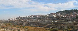
Efrat
Efrat
|
||
|---|---|---|
| Hebrew transcription(s) | ||
| • ISO 259 | ʔeprat, ʔepráta | |
| • Also spelled | Efrata (previously) (official) | |

Efrat, 2012
|
||
|
||
| Coordinates: 31°39′28.8″N 35°9′11.16″E / 31.658000°N 35.1531000°ECoordinates: 31°39′28.8″N 35°9′11.16″E / 31.658000°N 35.1531000°E | ||
| Region | West Bank | |
| District | Judea and Samaria Area | |
| Founded | 1983 | |
| Government | ||
| • Type | Local council | |
| • Head of Municipality | Oded Revivi | |
| Area | ||
| • Total | 6,280 dunams (6.28 km2 or 2.42 sq mi) | |
| Population (2015) | ||
| • Total | 8,301 | |
Efrat (Hebrew: אֶפְרָת), or previously officially Efrata (Hebrew: אֶפְרָתָה), is an Israeli settlement established in 1983 and a local council in the Judean Mountains of the West Bank. Efrat is located 12 kilometers (7.5 mi) south of Jerusalem, between Bethlehem and Hebron, 6.5 km (4 mi) east of the Green line, inside of the Security Barrier. The settlement rises to a height of 960 metres (3,150 feet) above sea level and covers about 6,000 dunam (1,500 acres). The international community considers Israeli settlements in the West Bank illegal under international law, but the Israeli government disputes this.
Considered the capital of Gush Etzion, it had a population of 8,301 in 2015. Although geographically located within Gush Etzion, it is independent from the Gush Etzion Regional Council, and Palestinians in negotiations do not consider it as part of that block, since it lies to the east of Route 60 — their side of the Geneva Initiative map. Since November 2008, Oded Ravivi, an attorney and lieutenant colonel in the army and member of the Likud Central Committee is the head of Efrat regional council.
...
Wikipedia


