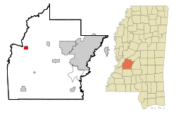
Edwards, Mississippi
| Edwards, Mississippi | |
|---|---|
| Town | |
 Location of Edwards, Mississippi |
|
| Location in the United States | |
| Coordinates: 32°19′51″N 90°36′15″W / 32.33083°N 90.60417°WCoordinates: 32°19′51″N 90°36′15″W / 32.33083°N 90.60417°W | |
| Country | United States |
| State | Mississippi |
| County | Hinds |
| Area | |
| • Total | 1.7 sq mi (4.3 km2) |
| • Land | 1.7 sq mi (4.3 km2) |
| • Water | 0.0 sq mi (0.0 km2) |
| Elevation | 236 ft (72 m) |
| Population (2000) | |
| • Total | 1,347 |
| • Density | 808.2/sq mi (312.1/km2) |
| Time zone | Central (CST) (UTC-6) |
| • Summer (DST) | CDT (UTC-5) |
| ZIP code | 39066 |
| Area code(s) | 601 |
| FIPS code | 28-21580 |
| GNIS feature ID | 0669683 |
Edwards is a town in Hinds County, Mississippi, United States. The population was 1,347 at the 2000 census. It is part of the Jackson Metropolitan Statistical Area.
Edwards is named for Dick Edwards, owner and proprietor of the Edwards House in Jackson, Mississippi.
Edwards was originally named Amsterdam and settled in the 1830s. In 1832 it suffered from a cholera epidemic and was then bypassed by the Alabama and Vicksburg Rail Road. This happened in 1839 when R. O. Edwards plantation became a stop on the railroad known as Edwards Depot.
The depot was burned to prevent its use during the Civil War in 1863. The current site of Edwards was chosen in 1866 and was incorporated in 1871.
In 1882 the Southern Christian Institute was opened by the Christian Church (Disciples of Christ) in the town to educate African-Americans. It later became Bonner-Campbell College. In 1897 Edwards suffered an attack of yellow fever that killed many residents of the town.
Edwards is located at 32°19′51″N 90°36′15″W / 32.33083°N 90.60417°W (32.330942, -90.604091).
According to the United States Census Bureau, the town has a total area of 1.7 square miles (4.4 km2), all land.
...
Wikipedia

