Edmund, Wisconsin
| Edmund, Wisconsin | |
|---|---|
| Census-designated place | |

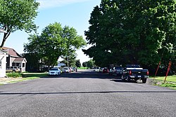
Looking down Main Street in Edmund
|
|
| Coordinates: 42°58′03″N 90°15′52″W / 42.96750°N 90.26444°WCoordinates: 42°58′03″N 90°15′52″W / 42.96750°N 90.26444°W | |
| Country | United States |
| State | Wisconsin |
| County | Iowa |
| Area | |
| • Total | 0.342 sq mi (0.89 km2) |
| • Land | 0.342 sq mi (0.89 km2) |
| • Water | 0 sq mi (0 km2) |
| Elevation | 1,204 ft (367 m) |
| Population (2010) | |
| • Total | 173 |
| • Density | 510/sq mi (200/km2) |
| Time zone | Central (CST) (UTC-6) |
| • Summer (DST) | CDT (UTC-5) |
| Area code(s) | 608 |
| GNIS feature ID | 1564455 |
Edmund is an unincorporated census-designated place located in the town of Linden in Iowa County, Wisconsin, United States. Edmund is located on U.S. Route 18 west of Dodgeville. The community's post office closed on November 2, 2002. As of the 2010 census, Edmund's population was 173.
Edmund got its name in 1881 from Edmund V. Baker who owned the land where the settlement was located.
...
Wikipedia

