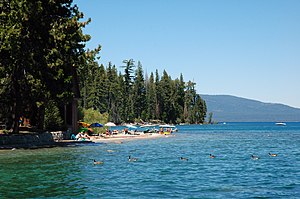
Ed Z'berg Sugar Pine Point State Park
| Ed Z'berg Sugar Pine Point State Park | |
|---|---|

|
|
| Location | El Dorado County, California |
| Nearest city | Tahoma, California |
| Coordinates | 39°03′27″N 120°07′21″W / 39.05750°N 120.12250°WCoordinates: 39°03′27″N 120°07′21″W / 39.05750°N 120.12250°W |
| Area | 1,000 hectares (2,500 acres) |
| Established | 1965 |
| Governing body | |
|
Ed Z'berg Sugar Pine Point State Park
|
|
| NRHP Reference # | 73000401 |
| Added to NRHP | March 30, 1973 |
California Department of Parks and Recreation
Ed Z'berg Sugar Pine Point State Park is a state park in California in the United States. It occupies nearly two miles of the western shore of Lake Tahoe and a total of about 1,000 hectares (2,500 acres) of forested mountains in El Dorado County. Originally called Sugar Pine Point State Park, its name was changed in 2003 to honor Edwin L. Z'berg, a California state assemblyman who specialized in environmental legislation and worked to develop state parks and other natural areas.
The park is in the high Sierra Nevada mountain range at an elevation of around 1,900 metres (6,200 ft). It is covered in mixed coniferous forest with tree species such as Jeffrey pine (Pinus jeffreyi), white fir (Abies concolor), Sierra lodgepole pine (Pinus contorta ssp. murrayana), California incense cedar (Calocedrus decurrens), sugar pine (Pinus lambertiana), and red fir (Abies magnifica).Black cottonwood (Populus trichocarpa) and quaking aspen (Populus tremuloides) are part of the local fall foliage display. This forest is not pristine, having been subjected to heavy logging in the late 1800s. Wood was used by miners in the and other great mineral deposits. Long-term fire suppression and periods of drought and bark beetle infestation have altered the fire regime. Controlled burns are used to help prevent very destructive wildfires.
...
Wikipedia


