Easton Bavents
| Easton Bavents | |
|---|---|
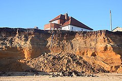
 Cliff fall at Easton Bavents |
|
| Easton Bavents shown within Suffolk | |
| OS grid reference | TM512775 |
| Civil parish |
|
| District | |
| Shire county | |
| Region | |
| Country | England |
| Sovereign state | United Kingdom |
| Post town | SOUTHWOLD |
| Postcode district | IP18 |
| Dialling code | 01502 |
| Police | Suffolk |
| Fire | Suffolk |
| Ambulance | East of England |
| EU Parliament | East of England |
| UK Parliament | |
Easton Bavents is a hamlet in Waveney District and the ceremonial county of Suffolk in England. It was once the most easterly ecclesiastical parish in England; a map of Suffolk dated around 1610 shows a headland projecting eastwards into the sea there. However, it is now restricted to a stretch of the Suffolk coast to the east of Reydon, as coastal erosion has caused the former village to be under the North Sea over 1 mile (1.6 km) east of that stretch. The remaining area is now part of the civil parish of Reydon.
During the Middle Ages Easton Bavents was a Parish of some importance and in the 14th Century it was granted a weekly market as well as a three-day-long fair on the feast day of St Nicholas. Records indicate that the parish church, also dedicated to St Nicholas was in use in 1639 and a rector was appointed as late as 1666. However, around that time, the cliff on which the village was built collapsed and the church itself seems to have gone under the sea during the latter part of the 17th Century. A Chapel dedicated to St Margaret was also erected but that too is now long gone.
The Battle of Sole Bay took place off the coast of Easton Bavents. Easton Bavents survived as a fishing village until the 19th Century.
The continuing receding of the cliffs makes the area a popular, albeit hazardous, area for fossil hunters who access the area by walking along the beach from Southwold.
...
Wikipedia

