Easterton
| Easterton | |
|---|---|
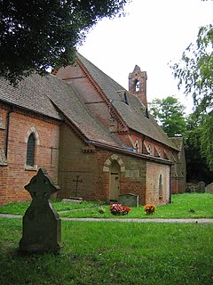
 St. Barnabas' parish church |
|
| Easterton shown within Wiltshire | |
| Population | 524 (in 2011) |
| OS grid reference | SU021550 |
| Civil parish |
|
| Unitary authority | |
| Ceremonial county | |
| Region | |
| Country | England |
| Sovereign state | United Kingdom |
| Post town | Devizes |
| Postcode district | SN10 |
| Dialling code | 01380 |
| Police | Wiltshire |
| Fire | Dorset and Wiltshire |
| Ambulance | South Western |
| EU Parliament | South West England |
| UK Parliament | |
Easterton is a village and civil parish in Wiltshire, England, 4 miles (6.4 km) south of Devizes. The parish includes the hamlets of Easterton Sands and Eastcott.
Easterton lies at the northern edge of Salisbury Plain.
The parish includes gault and greensand north-west of the road, and lower, middle and upper chalk zones ascending the slope south-eastwards on to the high plain. Across the parish run The Ridgeway along the scarp, the railway north of the greensand ridge, and the former turnpike road in between. This forms the village street, where it is bordered on the west side by a small brook. The street is in a hollow, so that gardens on the east side rise very steeply and have been terraced up the slope. Paths and lanes lead off the street to 'the Clays' on the east and 'the Sands' on the west. The main streets in the village are Oak Lane, Haywards Place, High Street, White Street, the Clay, Kings Road and Vicarage Lane.
Easterton is the site of a Roman villa estate, known from stray archaeological finds in the area of Kestrels in Oak Lane, west of the village. This may be linked with a mid 4th century Roman coin hoard, discovered in an urn during the 19th century and dispersed (although some coins passed to the Wiltshire Museum, Devizes). Another possible Roman site, deduced from place-name evidence, may lie at Wickham Green on the boundary with Urchfont some 2 km north of Kestrels.
Easterton's toponym is derived from the Old English for "the more easterly farm". It was a tithing which formed the eastern part of the ancient parish of East Lavington, now Market Lavington. Easterton was made a separate civil parish soon after its ecclesiastical parish was created in 1874, and in 1934 Eastcott hamlet was transferred to it from Urchfont parish.
...
Wikipedia

