Eastaboga, Alabama
| Eastaboga, Alabama | |
|---|---|
| Unincorporated community | |

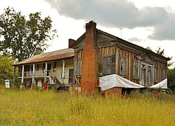
The Jemison House Complex is located in Eastaboga, Alabama. It was built c. 1840 and placed on the National Register of Historic Places on October 1, 1990
|
|
| Coordinates: 33°36′21″N 86°01′17″W / 33.60583°N 86.02139°WCoordinates: 33°36′21″N 86°01′17″W / 33.60583°N 86.02139°W | |
| Country | United States |
| State | Alabama |
| County | Calhoun |
| Elevation | 587 ft (179 m) |
| Time zone | Central (CST) (UTC-6) |
| • Summer (DST) | CDT (UTC-5) |
| Area code(s) | 256 & 938 |
| GNIS feature ID | 157941 |
Eastaboga is an Unincorporated community on the border of Talladega and Calhoun counties in the U.S. state of Alabama. It was previously called McFall, named for a settling family in the 1850s, and incorporated in 1898, only to be disincorporated in 1901. The original community of Eastaboga was to the south and became known as Old Eastaboga after McFall's name was changed to Eastaboga.
Eastaboga (historically Estaboga) means "where the people reside" in Muscogee, a Native American language.
The present unincorporated community of Eastaboga was listed as the incorporated town of McFall on the 1900 census, and had 820 residents. Of that, a majority, 482, lived on the Talladega County side, and 338 lived on the Calhoun County side. It was disincorporated after just 3 years in 1901 and the post office closed under that name in 1906. At some point on, it was renamed Eastaboga (while the nearby community to the south of the same name became "Old Eastaboga").
...
Wikipedia


