East Siang
| East Siang district | |
|---|---|
| District of Arunachal Pradesh | |
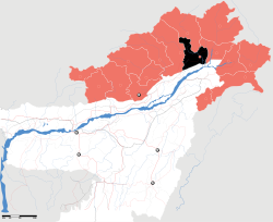
 Location of East Siang district in Arunachal Pradesh |
|
| Country | India |
| State | Arunachal Pradesh |
| Headquarters | Pasighat |
| Government | |
| • Lok Sabha constituencies | Ninong Ering |
| • Assembly seats | Tatung Jamoh, Kaling Moyong, Tapang Taloh |
| Area | |
| • Total | 4,005 km2 (1,546 sq mi) |
| Population (2011) | |
| • Total | 99,019 (2,011) |
| • Urban | Yes |
| Demographics | |
| • Literacy | 73.5% |
| • Sex ratio | 962 |
| Major highways | NH-52 |
| Website | Official website |
East Siang (Pron:/ˈsjæŋ or ˈsɪæŋ/) is an administrative district in the state of Arunachal Pradesh in India.
In 1989 territory was transferred from West Siang district to East Siang. A decade later, in 1999, the district was bifurcated to make Upper Siang district.
The district headquarters are located at Pasighat. East Siang district occupies an area of 4,005 square kilometres (1,546 sq mi), comparatively equivalent to Indonesia's Nias Island.
There are 5 Arunachal Pradesh Legislative Assembly constituencies located in this district: Panging, Nari-Koyu, Pasighat West, Pasighat East, and Mebo. All of these are part of Arunachal East Lok Sabha constituency.
According to the 2011 census East Siang district has a population of 99,214, roughly equal to the nation of Kiribati. This gives it a ranking of 615th in India (out of a total of 640). The district has a population density of 27 inhabitants per square kilometre (70/sq mi) . Its population growth rate over the decade 2001–2011 was 13.3%. East Siang has a sex ratio of 962 females for every 1000 males, and a literacy rate of 73.54%.
Various tribal groups of the Adi people live in various parts of the district. The local people traditionally follow Donyi-Polo, although a sizeable minority have converted to Christianity.
...
Wikipedia
