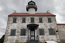
East Point Light

East Point Light
|
|
| Location | Lighthouse Road, near the jct. of East Point Road, Maurice River Township, New Jersey |
|---|---|
| Coordinates | 39°11′45″N 75°1′38″W / 39.19583°N 75.02722°WCoordinates: 39°11′45″N 75°1′38″W / 39.19583°N 75.02722°W |
| Year first constructed | 1849 |
| Year first lit | 1849 |
| Deactivated | 1941-1980 |
| Foundation | Stone |
| Construction | Brick |
| Tower shape | Octagonal on roof of rectangular building |
| Height | 40 feet (12.2 m) |
| Original lens | Sixth order Fresnel lens |
| Characteristic | |
|
Maurice River Lighthouse
|
|
| Area | 3.6 acres (1.5 ha) |
| Architect | Middleton, N. & S. |
| NRHP Reference # | 95001047 |
| NJRHP # | |
| Added to NRHP | August 25, 1995 |
| Heritage | place listed on the National Register of Historic Places |
|
[]
|
|
The East Point Light, known as the Maurice River Light before 1913, is a lighthouse located in Heislerville, New Jersey on Delaware Bay at the mouth of the Maurice River in Maurice River Township, Cumberland County, New Jersey, United States. The light was inactive from 1941 and was nearly destroyed by fire in 1971. The light was reinstated by the United States Coast Guard in 1980. Exterior restoration was completed in 1999.
Listed in the National Register of Historic Places as Maurice River Lighthouse, reference #95001047.
...
Wikipedia

