East Norwalk
| East Norwalk, Connecticut | |
|---|---|
| Neighborhood | |

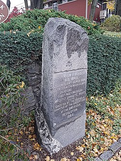
Founding Monument in East Norwalk
|
|
| Country |
|
| State |
|
| County | Fairfield |
| City | Norwalk |
| Time zone | Eastern (UTC-5:00) |
| • Summer (DST) | Eastern (UTC-4:00) |
| Area code(s) | 475, 203 |
East Norwalk is a neighborhood of Norwalk, Connecticut, located mostly in Norwalk's third taxing district with segments of its northernmost area within the first and fifth taxing districts. As one of the earliest settlements of Norwalk, it was so marked with a block of 'suitably inscribed' 'native granite' formally located on the corner of Fitch Street and East Avenue.
East Norwalk is the location of Norwalk's original colonial settlements. The land was purchased from the Norwalke Indians by Roger Ludlow in 1640. Historical markers in the neighborhood include the Founding Monument on East Ave and the First Settlers Monument inside the East Norwalk Historical Cemetery.
British forces under General William Tryon arrived on July 10, 1779 at Fitch's Point and destroyed most of Norwalk by fire; only six houses were spared. A portion of the Thomas Fitch (governor) house was left standing and in the 1950s it was moved to the Mill Hill Historic Park to make way for the construction of the Connecticut turnpike (I-95).
In 1913, East Norwalk combined with the Town of Norwalk, the City (formerly Borough) of Norwalk, and the city of South Norwalk into the present day City of Norwalk. East Norwalk is now within the city's third taxing district.
• East Norwalk Association: "The East Norwalk Improvement Association was founded in 1910 and "rebranded" as the East Norwalk Association in 2013. The Association has been active in East Norwalk continuously for more than 100 years and founded its East Norwalk Association Library in 1915."
• Eastern Norwalk Neighborhood Association: Formerly the East Norwalk Neighborhood Association which began in 2001 as 'VZSHAN', Van Zant to Sunset Hill Association of Neighbors formed to address zoning, development, traffic and other “quality of life” concerns shared by residents in neighborhoods along East Avenue on both sides of the Interstate.
Norwalk's neighborhoods do not have official status, and as such are boundary deficient. Nonetheless, East Norwalk's location within the city of Norwalk can be roughly described as being south of Interstate 95, east of the Norwalk River, north of a line from the Norwalk River along 5th Street to Gregory Boulevard, west of a line along Gregory Boulevard to Emerson Street then along Stanley Street then along Strawberry Hill Avenue back to Interstate 95.
...
Wikipedia
