East Greenville, Pennsylvania
| Borough of East Greenville | |
| Borough | |
| Country | United States |
|---|---|
| State | Pennsylvania |
| County | Montgomery |
| Elevation | 410 ft (125.0 m) |
| Coordinates | 40°24′20″N 75°30′15″W / 40.40556°N 75.50417°WCoordinates: 40°24′20″N 75°30′15″W / 40.40556°N 75.50417°W |
| Area | 0.5 sq mi (1.3 km2) |
| - land | 0.5 sq mi (1 km2) |
| - water | 0.0 sq mi (0 km2), 0% |
| Population | 5,424 (2010) |
| Density | 5,978.9/sq mi (2,308.5/km2) |
| Government | Council-manager |
| Mayor | Ryan J. Sloyer |
| Timezone | EST (UTC-5) |
| - summer (DST) | EDT (UTC-4) |
| ZIP Code | 18041 |
| Area code | 215, 610 |
|
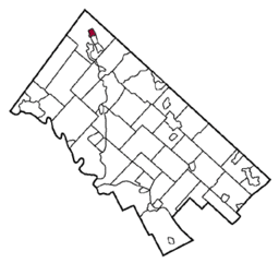
Location of East Greenville in Montgomery County
|
|
|
Website: www |
|
East Greenville is a borough in Montgomery County, Pennsylvania, United States. The population was 2,951 at the 2010 census.
It is part of the Upper Perkiomen School District.
It is part of the strip of small towns that run together along Route 29; Red Hill, Pennsburg and East Greenville.
East Greenville is located at 40°24′20″N 75°30′15″W / 40.40556°N 75.50417°W (40.405626, -75.504144).
According to the United States Census Bureau, the borough has a total area of 0.5 square miles (1.3 km2), all of it land.
As of the 2010 census, the borough was 93.7% White, 2.3% Black or African American, 0.1% Native American, 1.0% Asian, and 1.9% were two or more races. 3.3% of the population were of Hispanic or Latino ancestry [1].
As of the census of 2000, there were 3,103 people, 1,124 households, and 805 families residing in the borough. The population density was 5,978.9 people per square mile (2,304.0/km2). There were 1,173 housing units at an average density of 2,260.1 per square mile (871.0/km2). The racial makeup of the borough was 96.78% White, 0.90% African American, 0.13% Native American, 0.52% Asian, 0.90% from other races, and 0.77% from two or more races. Hispanic or Latino of any race were 2.64% of the population.
...
Wikipedia


