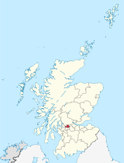
East Dunbartonshire
| East Dunbartonshire Aest Dunbartanshire Siorrachd Dhùn Bhreatainn an Ear |
|
|---|---|
 |
|
| Coordinates: 55°56′N 4°13′W / 55.933°N 4.217°WCoordinates: 55°56′N 4°13′W / 55.933°N 4.217°W | |
| Admin HQ | Kirkintilloch |
| Government | |
| • Body |
East Dunbartonshire Council |
| • Control | Lab + LD + Con (council NOC) |
| • MPs |
|
| • MSPs |
|
| Area | |
| • Total | 68 sq mi (175 km2) |
| Area rank | Ranked 26th |
| Population (2010 est.) | |
| • Total | 105,000 |
| • Rank | Ranked 20th |
| • Density | 1,550/sq mi (599/km2) |
| ONS code | 00QL |
| ISO 3166 code | GB-EDU |
| Website | http://www.eastdunbarton.gov.uk/ |
East Dunbartonshire (Scots: Aest Dunbartanshire; Scottish Gaelic: Siorrachd Dhùn Bhreatainn an Ear) is one of the 32 council areas of Scotland. It borders onto the north-west of the City of Glasgow. It contains many of the suburbs of Glasgow as well as many of the city's commuter towns and villages. East Dunbartonshire also shares a border with North Lanarkshire, Stirling and West Dunbartonshire. The council area covers part of the historic counties of Dunbartonshire, Lanarkshire and Stirlingshire.
The council area was formed in 1996, as a result of the Local Government etc. (Scotland) Act 1994, from part of the former Bearsden and Milngavie and Strathkelvin districts of the wider Strathclyde region.
East Dunbartonshire council area has low levels of deprivation, with relatively low unemployment and low levels of crime. The population is both declining and ageing.
In a 2007 Reader's Digest poll, East Dunbartonshire was voted the best place in Britain to raise a family. The area continually tops the Halifax Bank Quality of Life list. In 2010 East Dunbartonshire ranked 3rd in Scotland and was the only Scottish area in the British Top 20 in 2008 A Legatum Prosperity Index published by the Legatum Institute in October 2016 showed East Dunbartonshire as the most prosperous council area in Scotland and the ninth most prosperous in the United Kingdom.
...
Wikipedia
