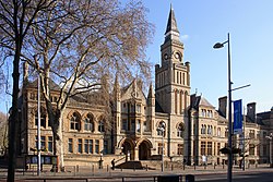
Ealing, London
| Ealing | |
|---|---|
 Ealing Town Hall in Ealing Broadway |
|
| Ealing shown within Greater London | |
| Population | 113,777 (Ealing Broadway, Ealing Common, Cleveland, Walpole, Hanger Hill, Northfield, Elthorne, and Hobbayne wards) |
| OS grid reference | TQ175805 |
| • Charing Cross | 7.9 mi (12.7 km) E |
| London borough | |
| Ceremonial county | Greater London |
| Region | |
| Country | England |
| Sovereign state | United Kingdom |
| Post town | LONDON |
| Postcode district | W5, W13 |
| Postcode district | NW10 |
| Dialling code | 020 |
| Police | Metropolitan |
| Fire | London |
| Ambulance | London |
| EU Parliament | London |
| UK Parliament | |
| London Assembly | |
Ealing (/ˈiːlɪŋ/) is a district of west London, England, located 7.9 miles (12.7 km) west of Charing Cross. It is the administrative centre of the London Borough of Ealing, and identified as a major metropolitan centre in the London Plan.
Ealing was historically a rural village in the county of Middlesex and formed an ancient parish. Improvement in communications with London, culminating with the opening of the railway station in 1838, shifted the local economy to market garden supply and eventually to suburban development.
As part of the growth of London in the 20th century, Ealing significantly expanded and increased in population, becoming a municipal borough in 1901 and has formed part of Greater London since 1965. It now forms a significant commercial and retail centre with a developed night time economy. Ealing has the characteristics of both suburban and inner-city developments. Ealing's town centre is often colloquial with Ealing Broadway, the name of both a rail interchange & a shopping centre.
Most of Ealing, including the commercial district, South Ealing, Ealing Common, Montpelier, Pitshanger and most of Hanger Hill fall under the W5 postcode. Areas to the north-west of the town centre such as Argyle Road and West Ealing fall under W13 instead. A small section north-east of the town centre, near Hanger Hill, falls under the NW10 postcode area. The population of Ealing (not including Hanwell and Northfields), comprising the Ealing Broadway, Ealing Common, Cleveland, Walpole and Hanger Hill wards, was 71,492 in the 2011 census. The area of Hanwell is strongly associated with Ealing; however, it is a separate district with its own postcode. Northfields on the other hand, despite sharing postcodes with Ealing is generally considered to be a separate area in its own right.
...
Wikipedia

