Eakring
| Eakring | |
|---|---|
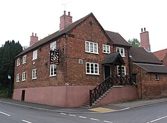
 Eakring – Savile Arms |
|
| Eakring shown within Nottinghamshire | |
| Population | 395 (2001) |
| OS grid reference | SK673623 |
| District | |
| Shire county | |
| Region | |
| Country | England |
| Sovereign state | United Kingdom |
| Post town | NEWARK |
| Postcode district | NG22 |
| Dialling code | 01623 |
| Police | Nottinghamshire |
| Fire | Nottinghamshire |
| Ambulance | East Midlands |
| EU Parliament | East Midlands |
| UK Parliament | |
Eakring is a village and civil parish in the Newark and Sherwood district in Nottinghamshire. The population of the civil parish was 395 at the 2011 Census, increasing to 419 at the 2011 Census.
It is situated between the A617 and the A616 roads between Ollerton and Southwell. Dukes Wood to the south is situated on the top of an escarpment, giving good views over the Trent valley to the east and towards Southwell to the south. Clouds formed by the Cottam Power Station are often seen on clear days to the north-east. A steep hill descends into the village from the south, on which the road passes a large residential training centre for National Grid plc.
The village pub is the Savile Arms on Bilsthorpe Road. The Robin Hood Way passes through the village.
Eakring Mill was a five-storey brick tower windmill, built some time after 1840 (grid reference SK673628). The sails were removed in 1912 and the mill was derelict by 1936. It was converted to a house in about 1995. A windmill was shown on a map of 1832, located in Mill Hill Field, where two footpaths cross, (grid reference SK668616) and another windmill shown north of Eakring Brail Wood (grid reference SK662614).
...
Wikipedia

