Dworshak Dam
| Dworshak Dam | |
|---|---|

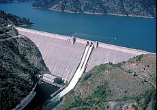
Dworshak Dam, with spillways open
|
|
|
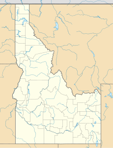
Location in north central Idaho
|
|
| Country | United States |
| Location | Clearwater County, Idaho |
| Coordinates | 46°30′54″N 116°17′46″W / 46.515°N 116.296°WCoordinates: 46°30′54″N 116°17′46″W / 46.515°N 116.296°W |
| Purpose | Water storage, power |
| Construction began | 1966 |
| Opening date | 1973 |
| Construction cost | $327 million |
| Owner(s) | U.S. Army Corps of Engineers |
| Dam and spillways | |
| Type of dam | Gravity dam |
| Impounds |
North Fork of the Clearwater River |
| Height | 717 ft (219 m) |
| Length | 3,287 ft (1,002 m) |
| Spillways | Service, 2x tainter gates |
| Spillway capacity | 150,000 cu ft/s (4,200 m3/s) |
| Reservoir | |
| Creates | Dworshak Reservoir |
| Total capacity | 3,468,000 acre·ft (4.278 km3) |
| Active capacity | 2,016,000 acre·ft (2.487 km3) |
| Catchment area | 2,440 sq mi (6,300 km2) |
| Surface area | 17,090 acres (6,920 ha) (max) |
| Normal elevation | 1,600 feet (490 m) AMSL |
| Power station | |
| Commission date | 1973 |
| Hydraulic head | 560 ft (170 m) |
| Turbines | 2x 90 MW 1x 220 MW |
| Installed capacity | 400 MW 460 MW (max. planned) |
| Annual generation | 1.693 billion KWh |
Dworshak Dam is a concrete gravity dam in the western United States, on the North Fork Clearwater River in Clearwater County, Idaho. The dam is located approximately 4 miles (6 km) northeast of Orofino and impounds the Dworshak Reservoir for flood control and hydroelectricity generation. With a height of 717 feet (219 m), Dworshak is the third tallest dam in the United States and the tallest straight-axis concrete dam in the Western Hemisphere. Construction of the dam by the U.S. Army Corps of Engineers (USACE) began in 1966 and was completed in 1973.
The proposal for Dworshak Dam originated in a 1953 USACE survey of the lower Snake River drainage basin for suitable sites to develop reservoir storage and hydroelectric power generation. Dworshak was one of seven dam sites considered on the Snake, Salmon and Clearwater River systems. The final site for Dworshak Dam was chosen at a point on the North Fork of the Clearwater 1.9 miles (3.1 km) above its confluence with the larger Clearwater River. The project was authorized on October 23, 1962 as Bruce's Eddy Dam; the name was later changed to honor U.S. Senator Henry Dworshak (1894–1962), who was instrumental in gaining congressional approval for the dam project.
The dam was controversial from the start because it would block fish migration and its reservoir would flood a large portion of the winter range of elk in the Clearwater River basin. The North Fork of the Clearwater River had an excellent run of steelhead trout and "may have been the finest population of large-size steelhead in the world". However, proponents of the project held that the construction of a fish hatchery would maintain the river's steelhead runs, and that the construction of the dam would render other dam projects in the Clearwater River basin unnecessary. Another big incentive for the project was flood control; supporters of Dworshak cited a devastating flood in 1948, when the Clearwater River reached a peak of 177,000 cubic feet per second (5,000 m3/s) – eleven times its normal flow – as further reason for the construction of a large storage dam.
...
Wikipedia


