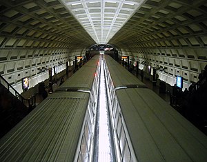
Dupont Circle (WMATA station)
| Washington Metro rapid transit station | |||||||||||
 |
|||||||||||
| Location | 1525 20th Street, NW Washington, DC 20036 |
||||||||||
| Coordinates | 38°54′34″N 77°02′37″W / 38.909499°N 77.04362°WCoordinates: 38°54′34″N 77°02′37″W / 38.909499°N 77.04362°W | ||||||||||
| Owned by | WMATA | ||||||||||
| Line(s) | |||||||||||
| Platforms | 2 side platforms | ||||||||||
| Tracks | 2 | ||||||||||
| Connections |
|
||||||||||
| Construction | |||||||||||
| Structure type | Underground | ||||||||||
| Bicycle facilities | 16 racks, 12 lockers | ||||||||||
| Disabled access | Yes | ||||||||||
| Other information | |||||||||||
| Station code | A03 | ||||||||||
| History | |||||||||||
| Opened | January 17, 1977 | ||||||||||
| Traffic | |||||||||||
| Passengers (2016) | 17,519 daily |
||||||||||
| Services | |||||||||||
|
|||||||||||
Dupont Circle is a station on the Red Line of the Washington Metro in Washington, D.C. Located below the circle of the same name, it is one of the busiest stations in the Metro system, with an average of 22,721 entries each weekday.
Dupont Circle station lies underneath the circle of the same name with an alignment directly under Connecticut Avenue NW between the southern edge of the circle to the south and Q Street NW to the north. The station's southernmost point is slightly more than two-and-a-half blocks north of Farragut North, making them two of the closest Metro stations (although Metro Center and Gallery Place are the closest in the system).
With service beginning on January 17, 1977, Dupont Circle station was the first station to open after the original stretch of the Red Line between Union Station and Farragut North. The station remained the western terminus of the Red Line until December 5, 1981, upon the extension of the line to Van Ness–UDC. On February 1, 2012, WMATA closed the southern entrance of the Metro station for at least 8 months to replace all three escalators that were deemed as some of the least reliable in the entire system. The south entrance reopened on October 21, 2012.
Dupont Circle station has two tracks with two side platforms; it is the last station heading west on the Red Line with this setup. Such a layout is required due to the depth of the station; its location below not only the Connecticut Avenue NW underpass but also an abandoned streetcar tunnel necessitated a single-bore tunnel to carry both tracks.
There are two entrances to Dupont Circle: one to the north on the south side of Q Street NW between Connecticut Avenue NW and 20th Street NW (closer to 20th Street NW), and one to the south on the southern edge of Dupont Circle between 19th Street NW and Connecticut Avenue NW (closer to 19th Street NW). Due to the station's depth, the station's north entrance escalators are 188 feet (57 m) long.
...
Wikipedia
