Dry Doddington
| Dry Doddington | |
|---|---|
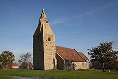
 Church of St James, Dry Doddington |
|
| Dry Doddington shown within Lincolnshire | |
| OS grid reference | SK850466 |
| • London | 105 mi (169 km) S |
| Civil parish | |
| District | |
| Shire county | |
| Region | |
| Country | England |
| Sovereign state | United Kingdom |
| Post town | Newark |
| Postcode district | NG23 |
| Police | Lincolnshire |
| Fire | Lincolnshire |
| Ambulance | East Midlands |
| EU Parliament | East Midlands |
| UK Parliament | |
Dry Doddington is a small village in the north-west of the South Kesteven district of Lincolnshire, England within the civil parish of Westborough and Dry Doddington. It is situated approximately 5 miles (8 km) south-east from Newark, approximately 8 miles (13 km) north-west from Grantham, and just over 1 mile (2 km) to the east from the A1 road.
Dry Doddington means the "dry estate of a man called Dodda". There was a deserted medieval village called 'Stocking' or 'Stockyng' associated with Dry Doddington in the early 14th century; its precise location is unknown.
Dry Doddington CE School was built as a National School in 1872, but was closed between 1926 and 1929, after which it re-opened as a primary school. It closed for the last time in 1961.
Today, the village forms part of the civil parish of Westborough and Dry Doddington, which had a population of 335 in 2001. Before 1931 Dry Doddington was a separate parish.
The village public house is The Wheatsheaf Inn on Main Street.
The village, on a small hill called Lincoln Hill, is surrounded by the River Witham to the west and south. The village of Claypole is to the north and Westborough and Long Bennington 1 mile (1.6 km) to the south. The East Coast Main Line passes 1 mile to the north-east.
...
Wikipedia

