Druridge Bay
| Druridge Bay | |
|---|---|

Druridge Bay
|
|
|
|
|
| OS grid reference | NZ276984 |
| Coordinates | 55°16′44″N 1°34′01″W / 55.279°N 1.56708°WCoordinates: 55°16′44″N 1°34′01″W / 55.279°N 1.56708°W |
|
|
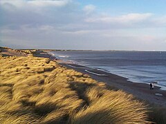
Druridge Bay is a 7 miles (11 km) long bay on the North Sea in Northumberland, England, stretching from Amble in the north to Cresswell in the south.
Northumberland Coast Country Park is situated on the bay, and part of the bay (the section near the farm-steading of Druridge, in the centre of the bay) is owned by the National Trust. Coastal areas on the bay are set aside as nature reserves.
During World War II, defences were constructed around Druridge Bay as part of the anti-invasion preparations. The defences included scaffolding barriers and anti-tank blocks overlooked by pillboxes; and behind these were minefields and an anti-tank ditch.
Between the hamlets of Druridge and Cresswell, anti-glider ditches were dug and there is an extant brick-built decoy control.
The bay was the focus of a long-running campaign against proposals to construct a Pressurised Water Reactor nuclear power station during the 1980s and for the large-scale extraction of sand from the area in the 1990s. The first campaign, along with changes in UK Government policy on nuclear power, prevented the power station from being built: the plan was shelved in 1989.
The land was retained by Nuclear Electric and in February 1996 was allocated to the NDA/BNFL. In November 1996 the NDA/BNFL sold the land to farmers.
...
Wikipedia

