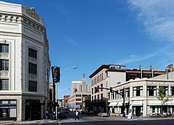
Downtown Providence Historic District
|
Downtown Providence Historic District
|
|
 |
|
| Location | Providence, Rhode Island |
|---|---|
| Coordinates | 41°49′N 71°25′W / 41.82°N 71.41°WCoordinates: 41°49′N 71°25′W / 41.82°N 71.41°W |
| Area | 90 acres (36 ha) |
| Built | 1800 |
| Architect | Multiple |
| Architectural style | Late 19th And Early 20th Century American Movements, Late Victorian, Other |
| NRHP Reference # |
(original) 07001081 (increase 1) 12000438 (increase 2) |
| Significant dates | |
| Added to NRHP | February 10, 1984 |
| Boundary increases | October 11, 2007 July 25, 2012 |
Downtown, also known as Downcity, is the central economic, political, and cultural district of the city of Providence, Rhode Island. It is bounded on the east by Canal Street and the Providence River, to the north by Smith Street, to the west by Interstate 95, and to the south by Henderson Street. I-95 serves as a physical barrier between the city's commercial core and neighborhoods of Federal Hill, West End, and Upper South Providence. Most of the downtown is listed on the National Register of Historic Places as the Downtown Providence Historic District.
Originally known as 'Weybossett Neck' or 'Weybossett Side,' Downtown was first settled by religious dissidents from the First Congregational Society in 1746. Their settlement was located near present-day Westminster Street.
Downtown did not witness substantial development until the early 19th century, when Providence began to compete with Newport, Rhode Island. British forces had destroyed much of Newport during the American War for Independence, making the city's merchants vulnerable to competition from Providence. This prevented the development of a commercial district along the western bank of the Providence River.
During the industrialization of the late 19th century, an ever-expanding railroad industry emanating from Union Station, eventually resulted in the complete paving over of the Great Salt Cove and the two branches of the Providence River. The result of decades of expansion was the isolation of the state capitol from the rest of downtown by an imposing mass of railroad tracks, often called locally the "Chinese Wall". As rail traffic dropped off, 75 percent by 1980, city planners saw an opportunity to open up central land for development and unify downtown with the Capitol. A new, smaller train station was built in 1986 a half mile north of its predecessor, and tracks were removed or routed underground.
...
Wikipedia


