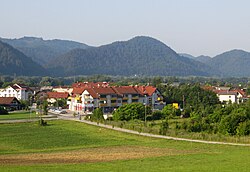
Dolsko
| Dolsko | |
|---|---|
 |
|
| Location in Slovenia | |
| Coordinates: 46°5′30.36″N 14°40′29.58″E / 46.0917667°N 14.6748833°ECoordinates: 46°5′30.36″N 14°40′29.58″E / 46.0917667°N 14.6748833°E | |
| Country |
|
| Traditional region | Upper Carniola |
| Statistical region | Central Slovenia |
| Municipality | Dol pri Ljubljani |
| Area | |
| • Total | 3.58 km2 (1.38 sq mi) |
| Elevation | 264.8 m (868.8 ft) |
| Population (2002) | |
| • Total | 467 |
Dolsko (pronounced [ˈdɔːu̯skɔ] or [ˈdɔːlskɔ]; in older sources also Dolško,German: Douschko) is a settlement northeast of Ljubljana in the Municipality of Dol pri Ljubljani in the Upper Carniola region of Slovenia.
Dolsko lies on the edge of a terrace 2 to 3 m high above the Sava River just west of the point where the Sava leaves the relatively flat Sava Basin and enters hilly territory. Mlinščica Creek (also known locally as Mežca Creek), a tributary of the Sava, flows through the southern outskirts of the settlement. The soil is sandy and fertile.
Dolsko was attested in written sources in 1763–87 as Dousko. The name is derived from a clipped noun phrase, Dolsko (selo/polje) '(village/field near) Dol'. Locally, the name is pronounced Dou̯škə.
A school was established in Dolsko in 1880, and the schoolhouse was expanded with the addition of a second floor in 1904. The cemetery east of Dolsko was formerly used to bury drowning victims taken from the Sava River.
The local church, built outside the settlement, is dedicated to Saint Agatha. It was formerly dedicated to Saint Thaïs (Slovene: sveta Tajda). It is located south of the road east of the village. The nave of the church is decorated with painting of the Ascension, and the church also has stained glass windows and a stone altar. The cemetery chapel dates from 1500 and was reworked several times, most extensively around 1900. The bell tower was built between 1902 and 1905. The tower contains two bells dating from the first half of the 15th century.
...
Wikipedia

