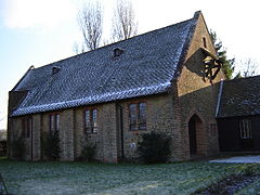
Dockenfield
| Dockenfield | |
|---|---|
 Church of the Good Shepherd, built in 1910 |
|
| Dockenfield shown within Surrey | |
| Area | 2.73 km2 (1.05 sq mi) |
| Population | 399 (Civil Parish 2011) |
| • Density | 146/km2 (380/sq mi) |
| OS grid reference | SU8340 |
| Civil parish |
|
| District | |
| Shire county | |
| Region | |
| Country | England |
| Sovereign state | United Kingdom |
| Post town | Godalming |
| Postcode district | GU10 4 |
| Dialling code | 01483 |
| Police | Surrey |
| Fire | Surrey |
| Ambulance | South East Coast |
| EU Parliament | South East England |
| UK Parliament | |
Dockenfield is a linear settlement and rural civil parish in the borough of Waverley in Surrey, England. The parish is undulating, has a number of sources of the River Wey and borders the Alice Holt Forest.
Until 1894 it had an unusual county, as a tything in Hampshire that was part of the parish of Frensham – Frensham's lands were part of Farnham at the Norman Conquest and supported the Bishops of Winchester who lived at Farnham Castle after one arranged its construction in 1138 – in 1239 Frensham gained its own parish, its ecclesiastical parish as used by the Church of England.
Dockenfield, was one of the unnamed tythings of Farnham owned by the Bishop of Winchester in 1086 and the Domesday Book confirms the tythings as his at the time of the Norman Conquest. At that time the area's largely agricultural workers rendered £55, much more than £51704 per year to him (based on inflation since 1264 starting year for UK economic valuations). The Bishop of Winchester built Farnham Castle to live in, and he and his successors did so from 1138.
In 1239 the ecclesiastical parish was created and first church built, which still remains the parish in Anglicanism: Frensham, Surrey. Frensham is a scattered village centred 1 mile (1.6 km) east, that also covers Millbridge and Shortfield Common/Spreakley, which are its hamlets much closer to its centre.
...
Wikipedia

