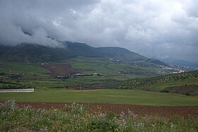
Djebel Babor
| Babor Range | |
|---|---|
| جبل البابور / Monts des Babors | |

View of the Babor Range near Bouqaa
|
|
| Highest point | |
| Peak | Mount Babor |
| Elevation | 2,004 m (6,575 ft) |
| Coordinates | 36°33′0″N 5°28′0″E / 36.55000°N 5.46667°ECoordinates: 36°33′0″N 5°28′0″E / 36.55000°N 5.46667°E |
| Geography | |
|
[Petite Kabylie]], Algeria
|
|
| Parent range | Tell Atlas |
The Babor Range (Arabic: جبل البابور; French: Monts des Babors) is a mountain range of the Tell Atlas in Algeria. The highest point of the range is 2,004 m high Mount Babor.
The Babor Range, together with the neighboring Bibans, is part of the mountainous natural region of Petite Kabylie.
There is a protected area in the range, the Djebel Babor Nature Reserve, known for birdwatching. It is also one of the few remaining habitats for the endangered Barbary macaque, Macaca sylvanus.
View of Mansoura, Bordj-Bou-Arreridj Province
The Air Algerie Boeing 737-2T4/Adv named "Monts des Babors"
...
Wikipedia

