District Council of Peterborough
|
District Council of Peterborough South Australia |
|||||||||||||
|---|---|---|---|---|---|---|---|---|---|---|---|---|---|

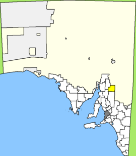
Location of District Council of Peterborough
|
|||||||||||||
| Population | 1,673 (2015 est) | ||||||||||||
| • Density | 0.5540/km2 (1.4348/sq mi) | ||||||||||||
| Established | 1935 | ||||||||||||
| Area | 3,020 km2 (1,166.0 sq mi) | ||||||||||||
| Mayor | Ruth Whittle | ||||||||||||
| Council seat | Peterborough | ||||||||||||
| Region | Yorke and Mid North | ||||||||||||
| State electorate(s) | Stuart | ||||||||||||
| Federal Division(s) | Grey | ||||||||||||
| Website | District Council of Peterborough | ||||||||||||
|
|||||||||||||
The District Council of Peterborough is a local government area in the Yorke and Mid North region of South Australia. The principal town and council seat is Peterborough; it also includes the localities of Cavenagh, Dawson, Hardy, Minvalara, Nackara, Oodla Wirra, Paratoo, Parnaroo, Sunnybrae, Ucolta and Yongala.
It was formed on 21 March 1935, when the District Council of Coglin and the District Council of Yongala merged with part of the Corporate Town of Peterborough to create the new council. The remainder of the Corporate Town of Peterborough continued on as an independent municipality surrounded by the District Council until the two were amalgamated in 1997. It still operates out of the heritage-listed 1927 Peterborough Town Hall.
The District Council of Peterborough has a directly-elected mayor.
Coordinates: 32°58′25″S 138°50′17″E / 32.973510°S 138.838093°E
...
Wikipedia
