Diesse
| Diesse | ||
|---|---|---|
| Former municipality of Switzerland | ||

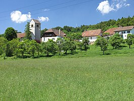
View from the Chasseral toward Diesse village and Nods
|
||
|
||
| Coordinates: 47°7′N 7°7′E / 47.117°N 7.117°ECoordinates: 47°7′N 7°7′E / 47.117°N 7.117°E | ||
| Country | Switzerland | |
| Canton | Bern | |
| District | Jura bernois | |
| Area | ||
| • Total | 9.48 km2 (3.66 sq mi) | |
| Elevation | 838 m (2,749 ft) | |
| Population (Dec 2011) | ||
| • Total | 436 | |
| • Density | 46/km2 (120/sq mi) | |
| Postal code | 2517 | |
| SFOS number | 0721 | |
| Surrounded by | Prêles, Lamboing, Nods | |
| Website |
www SFSO statistics |
|
Diesse is a former municipality in the Jura bernois administrative district in the canton of Bern in Switzerland, located in the French-speaking Bernese Jura (Jura Bernois).
The proposed merger of the municipalities of Diesse, Lamboing, Nods, and Prêles into the new municipality of Le Plateau de Diesse was rejected by voters. However, on 1 January 2014 the former municipalities of Diesse, Lamboing, and Prêles merged into the new municipality of Plateau de Diesse.
Diesse is first mentioned in 1178 as Diesse. In German it was known as Tess though this name is no longer commonly used.
The parish church of Diesse was first mentioned in 1185. Beginning in 1530 the Protestant Reformation gradually gained power until the parish switched to the new faith in 1554. Until 1798, Diesse was the capital of the district of Tessenberg. Following the 1798 French invasion, Diesse became part of France and remained so until the Congress of Vienna returned it to Bern. The village school was built in 1850-56. The village's population slowly declined until the 1980s, when commuters to the surrounding towns began to move into Diesse.
Before the merger, Diesse had a total area of 9.5 km2 (3.7 sq mi). As of 2012, a total of 4.54 km2 (1.75 sq mi) or 47.9% is used for agricultural purposes, while 4.47 km2 (1.73 sq mi) or 47.2% is forested. Of the rest of the land, 0.43 km2 (0.17 sq mi) or 4.5% is settled (buildings or roads), and 0.01 km2 (2.5 acres) or 0.1% is unproductive land.
During the same year, housing and buildings made up 1.5%, and transportation infrastructure made up 2.3%. Out of the forested land, 43.0% of the total land area is heavily forested, and 4.1% is covered with orchards or small clusters of trees. Of the agricultural land, 21.9% is used for growing crops, 10.5% is pastureland, and 15.2% is used for alpine pasture.
...
Wikipedia


