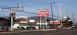
Devore, California
| Devore | |
|---|---|
| Unincorporated community | |
| Devore Heights | |

Roadside business in Devore along former historic U.S. Route 66 (Cajon Boulevard)
|
|
| Location within the state of California | |
| Coordinates: 34°12′59″N 117°24′05″W / 34.21639°N 117.40139°WCoordinates: 34°12′59″N 117°24′05″W / 34.21639°N 117.40139°W | |
| Country | United States |
| State | California |
| County | San Bernardino County |
| Elevation | 2,510 ft (770 m) |
| Time zone | Pacific (PST) (UTC-8) |
| • Summer (DST) | PDT (UTC-7) |
| ZIP codes | 92407 |
| Area code(s) | 909 |
| GNIS feature ID | 270868 |
Devore Heights or Devore is a rural and mountainous unincorporated community in San Bernardino County, California. It is located just outside the San Bernardino city limits near the northern junction of Interstate 15 and Interstate 215 about 12 miles north-west of downtown San Bernardino. The area is just outside the boundaries of the San Bernardino National Forest; nearby cities/town centers include Verdemont, Universitytown, Fontana, and Rialto. San Manuel Amphitheater, the largest amphitheater in North America, is located in Devore, San Bernardino. Devore is in the 92407 ZIP Code and is within the 909 area code. Devore, is served by the San Bernardino City Unified School District. Devore is home to Kimbark Elementary, while no middle or high schools are located within the neighborhood, the nearby neighborhoods of Verdemont and Universitytown hold a middle school and high school respectively.
...
Wikipedia

