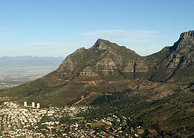
Devil's Peak, Cape Town
| Devil's Peak | |
|---|---|

Devil's Peak seen from Lion's Head. Hottentots Holland range in the distance
|
|
| Highest point | |
| Elevation | 1,000 m (3,300 ft) |
| Coordinates | 33°57′17.11″S 18°26′21.35″E / 33.9547528°S 18.4392639°ECoordinates: 33°57′17.11″S 18°26′21.35″E / 33.9547528°S 18.4392639°E |
| Geography | |
| Location | Western Cape, South Africa |
| Geology | |
| Age of rock | Silurian/Ordovician |
| Climbing | |
| Easiest route | Hike |
Devil's Peak is part of the mountainous backdrop to Cape Town, South Africa. When looking at Table Mountain from the Victoria & Alfred Waterfront, or when looking at the standard picture postcard view of the mountain, the skyline is from left to right: the spire of Devil's Peak, the flat mesa of Table Mountain, the dome of Lion's Head and Signal Hill.
The central districts of Cape Town are nestled within this natural amphitheatre. The city grew out of a settlement founded on the shore below the mountains in 1652 by Jan van Riebeeck, for the Dutch East India Company. Some of the first farms in the Cape were established on the slopes of Devils Peak, along the Liesbeek River.
Devil's Peak stands 1,000 metres (3,281 ft) high, less than Table Mountain's 1,087 metres (3,566 ft). One can walk to the top (western slopes provide the easiest approach) but the ascent is more pleasant and safer outside of the cold, wet, winter months of May to August.
The Rhodes Memorial to Cecil Rhodes, and the University of Cape Town are situated on the eastern slopes of Devil's Peak. From these vantages one can gaze down upon the southern suburbs of Cape Town and over the sandy Cape Flats towards Stellenbosch, Somerset West, and the distant Boland mountains. Other landmarks on the eastern slopes are Mostert's Mill, Groote Schuur Hospital, and the Groote Schuur estate, including a number of presidential and ministerial residences.
...
Wikipedia
