Desecheo Island

Satellite Image
|
|
| Geography | |
|---|---|
| Coordinates | 18°23′14″N 67°28′19″W / 18.38722°N 67.47194°W |
| Area | 1.524613 km2 (0.588656 sq mi) |
| Length | 1.8 km (1.12 mi) |
| Width | 1.1 km (0.68 mi) |
| Highest elevation | 218 m (715 ft) |
| Highest point | Sego Can Ridge |
| Administration | |
|
United States
|
|
| Commonwealth | Puerto Rico |
| Municipio | Mayagüez |
| Barrio | Sabanetas |
| Demographics | |
| Population | 0 |
| Pop. density | 0 /km2 (0 /sq mi) |
Coordinates: 18°23′14″N 67°28′19″W / 18.38722°N 67.47194°W
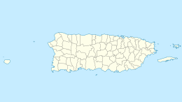
Desecheo (Spanish pronunciation: [deseˈtʃeo]) is a small uninhabited island of the archipelago of Puerto Rico located in the northeast of the Mona Passage; 21 km from the west coast (Punta Higüero) of the main island of Puerto Rico and 50 km northeast of Mona Island. It has a land area of 1.5 km2 (exactly 1,524,613 m2, or 0.589 sq mi, or 376.74 acres). Politically, the island is administered by the U.S. Department of the Interior, U.S. Fish and Wildlife Service.
Desecheo, which has no known bodies of surface water, reaches a maximum elevation of 218 m and has an annual precipitation, on average, of 1020 mm (40.15 in). The lack of surface water limits its flora to thorny shrubs, small trees, weeds and various cacti, including the endangered higo chumbo (Harrisia portoricensis). Fauna includes various species of seabirds, three endemic species of lizard (Ameiva desechensis, Anolis desechensis and Sphaerodactylus levinsi), introduced goats and rats, and a population of rhesus monkeys (Macaca mulatta) introduced from Cayo Santiago in 1967 as part of a study on adaptation. Before the introduction of rhesus monkeys the island was the largest nesting colony of the brown booby, however, no species presently nests on the island.
...
Wikipedia

