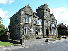
Denny, Falkirk
Denny
|
|
|---|---|
 Denny Town House, the former town hall |
|
| Denny shown within the Falkirk council area | |
| Area | 1.03 sq mi (2.7 km2) |
| Population | 7,933 (2008 est.) |
| • Density | 7,702/sq mi (2,974/km2) |
| OS grid reference | NS806818 |
| • Edinburgh | 28.5 mi (45.9 km) |
| • London | 348 mi (560 km) |
| Civil parish |
|
| Council area | |
| Lieutenancy area | |
| Country | Scotland |
| Sovereign state | United Kingdom |
| Post town | DENNY |
| Postcode district | FK6 |
| Dialling code | 01324 |
| Police | Scottish |
| Fire | Scottish |
| Ambulance | Scottish |
| EU Parliament | Scotland |
| UK Parliament | |
| Scottish Parliament | |
| Website | falkirk.gov.uk |
Denny (Scottish Gaelic: Deanaidh) is a town in the Falkirk council area of Scotland, formerly in the county of Stirlingshire. It is situated 7 miles (11 km) west of Falkirk, and 6 miles (9.7 km) north-east of Cumbernauld, adjacent to both the M80 and M876 motorways. At the 2011 census, Denny had a resident population of 7,933.
Denny is separated from neighbouring village Dunipace by the River Carron. Until the early 1980s, Denny was a centre for heavy industry, including several iron foundries, brickworks, a coal mine and paper mills.
Denny is currently going through a £7.6 million regeneration scheme in the town centre.[1]
The local football team are Dunipace Juniors F.C., who play at Westfield Park where they moved to from their previous home of Carronbank. They compete in the West Region of the Scottish Junior Football Association.
Notable sports people from Denny include:
...
Wikipedia

