Deniliquin, New South Wales
|
Deniliquin New South Wales |
|||||||
|---|---|---|---|---|---|---|---|

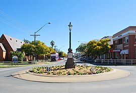
Deniliquin town centre
|
|||||||
| Coordinates | 35°32′0″S 144°58′0″E / 35.53333°S 144.96667°ECoordinates: 35°32′0″S 144°58′0″E / 35.53333°S 144.96667°E | ||||||
| Population | 7,494 (2011 census) | ||||||
| Postcode(s) | 2710 | ||||||
| Elevation | 93.0 m (305 ft) | ||||||
| Location | |||||||
| LGA(s) | Edward River Council | ||||||
| County | Townsend | ||||||
| State electorate(s) | Murray | ||||||
| Federal Division(s) | Farrer | ||||||
|
|||||||
Deniliquin, /dəˈnɪlᵻkwᵻn/ known locally as "Deni", is a town in the Riverina region of New South Wales close to the border with Victoria. It is the largest town in the Edward River Council local government area.
Deniliquin is located at the intersection of the Riverina and Cobb Highway approximately 725 kilometres (450 mi) south west of the state capital, Sydney and 285 kilometres (177 mi) north of Melbourne. The town is divided in two parts by the Edward River, an anabranch of the Murray River, with the main business district located on the south bank.
The town services a productive agricultural district with prominent rice, wool and timber industries. In the 2011 census, the population of Deniliquin was 7,494.
Prior to European settlement, the Aboriginal inhabitants of the Deniliquin area were the Barapa Baraba people.
In 1843 the entrepreneur and speculator Benjamin Boyd acquired land in the vicinity of present-day Deniliquin (probably via his agent Augustus Morris). The location was known as The Sandhills, but Boyd (or Morris) named it Deniliquin after 'Denilakoon', a local Aborigine famed for his wrestling prowess. An inn and a punt were established on the site in the period 1845-47 and the town site was surveyed in 1848 and gazetted in 1850. Deniliquin Post Office opened on 1 January 1850.
...
Wikipedia

