Delley-Portalban
| Delley-Portalban | ||
|---|---|---|

Church in Delley-Portalban
|
||
|
||
| Coordinates: 46°55′N 6°58′E / 46.917°N 6.967°ECoordinates: 46°55′N 6°58′E / 46.917°N 6.967°E | ||
| Country | Switzerland | |
| Canton | Fribourg | |
| District | Broye | |
| Government | ||
| • Mayor | Syndic | |
| Area | ||
| • Total | 7.26 km2 (2.80 sq mi) | |
| Elevation | 497 m (1,631 ft) | |
| Population (Dec 2015) | ||
| • Total | 1,066 | |
| • Density | 150/km2 (380/sq mi) | |
| Postal code | 1567 Delley 1568 Portalban |
|
| SFOS number | 2051 | |
| Surrounded by | Boudry (NE), Chabrey (VD), Gletterens, Neuchâtel (NE), Saint-Aubin, Vallon, Villars-le-Grand (VD) | |
| Website |
www SFSO statistics |
|
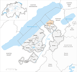
Delley-Portalban is a municipality in the district of Broye, in the canton of Fribourg, Switzerland. The municipality was created on 1 January 2005 from the merger of Delley and Portalban (Arpitan: ![]() Pouraban ).
Pouraban ).
Delley is first mentioned in 1342 as Deler. Portalban is first mentioned in 1166 as Portubanni.
Delley-Portalban has an area, as of 2009[update], of 7.3 square kilometers (2.8 sq mi). Of this area, 4.65 km2 (1.80 sq mi) or 64.0% is used for agricultural purposes, while 0.98 km2 (0.38 sq mi) or 13.5% is forested. Of the rest of the land, 0.87 km2 (0.34 sq mi) or 12.0% is settled (buildings or roads), 0.04 km2 (9.9 acres) or 0.6% is either rivers or lakes and 0.72 km2 (0.28 sq mi) or 9.9% is unproductive land.
Of the built up area, housing and buildings made up 7.3% and transportation infrastructure made up 2.8%. while parks, green belts and sports fields made up 1.7%. Out of the forested land, all of the forested land area is covered with heavy forests. Of the agricultural land, 58.3% is used for growing crops and 4.4% is pastures, while 1.4% is used for orchards or vine crops. All the water in the municipality is in lakes.
The municipality is located in the Broye district, directly connected to the main part of the Canton of Fribourg. It consists of the villages of Delley and Portalban and the hamlets of Grange-des-Bois, Portalban-Dessus and Moulin de Glâne.
...
Wikipedia


